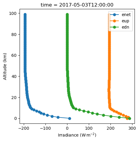
Quickstart: ERA5 Atmosphere#
In this notebook, we’ll use ERA5 reanalysis data from Google Cloud Storage to construct realistic atmospheric profiles for our simulations. Instead of relying on standard atmosphere models, we can simulate radiation transfer using actual temperature, humidity, and pressure profiles from a specific time and location.
Setup#
import numpy as np
import pandas as pd
import matplotlib.pyplot as plt
import xarray as xr
import gcsfs
import os
import logging
from pathlib import Path
from pyradtran.config import load_config

import pyradtran  # Registers the .pyradtran xarray accessor

# Suppress verbose solver output
logging.getLogger('pyradtran').setLevel(logging.DEBUG)
Loading ERA5 Data#
We use the ARCO ERA5 dataset hosted on Google Cloud Storage. ARCO (Analysis-Ready, Cloud-Optimized) ERA5 is a reformatted copy of ECMWF’s ERA5 reanalysis stored in Zarr format, making it fast to access directly from the cloud without downloading large files. This gives us access to global atmospheric profiles (temperature, humidity, pressure, etc.) at 0.25° resolution and hourly timesteps.
# pip install gcsfs  # Required for accessing ERA5 data from Google Cloud

gcs = gcsfs.GCSFileSystem(token="anon")

# Common ARCO ERA5 Zarr (newer "v3" store; large, but actively used)
path = "gs://gcp-public-data-arco-era5/ar/full_37-1h-0p25deg-chunk-1.zarr-v3"

ds = xr.open_zarr(
    gcs.get_mapper(path),
    chunks="auto",
    consolidated=True,
)
ds_sel = ds.sel(time='2017-05-03T12:00:00', latitude=51.33962, longitude=12.37129, method='nearest')
ds.close()
ds_sel
<xarray.Dataset> Size: 3kB
Dimensions:                                                          (level: 37)
Coordinates:
    latitude                                                         float32 4B ...
  * level                                                            (level) int64 296B ...
    longitude                                                        float32 4B ...
    time                                                             datetime64[ns] 8B ...
Data variables: (12/273)
    100m_u_component_of_wind                                         float32 4B dask.array<chunksize=(), meta=np.ndarray>
    100m_v_component_of_wind                                         float32 4B dask.array<chunksize=(), meta=np.ndarray>
    10m_u_component_of_neutral_wind                                  float32 4B dask.array<chunksize=(), meta=np.ndarray>
    10m_u_component_of_wind                                          float32 4B dask.array<chunksize=(), meta=np.ndarray>
    10m_v_component_of_neutral_wind                                  float32 4B dask.array<chunksize=(), meta=np.ndarray>
    10m_v_component_of_wind                                          float32 4B dask.array<chunksize=(), meta=np.ndarray>
    ...                                                               ...
    wave_spectral_directional_width_for_swell                        float32 4B dask.array<chunksize=(), meta=np.ndarray>
    wave_spectral_directional_width_for_wind_waves                   float32 4B dask.array<chunksize=(), meta=np.ndarray>
    wave_spectral_kurtosis                                           float32 4B dask.array<chunksize=(), meta=np.ndarray>
    wave_spectral_peakedness                                         float32 4B dask.array<chunksize=(), meta=np.ndarray>
    wave_spectral_skewness                                           float32 4B dask.array<chunksize=(), meta=np.ndarray>
    zero_degree_level                                                float32 4B dask.array<chunksize=(), meta=np.ndarray>
Attributes:
    last_updated:           2026-04-18 02:38:53.794831+00:00
    valid_time_start:       1940-01-01
    valid_time_stop:        2025-12-31
valid_time_stop_era5t: 2026-04-12- level: 37
- latitude()float3251.25
- long_name :
- latitude
- units :
- degrees_north
array(51.25, dtype=float32)
- level(level)int641 2 3 5 7 ... 900 925 950 975 1000
- long_name :
- level
- units :
- Hectopascal(hPa)
array([ 1, 2, 3, 5, 7, 10, 20, 30, 50, 70, 100, 125, 150, 175, 200, 225, 250, 300, 350, 400, 450, 500, 550, 600, 650, 700, 750, 775, 800, 825, 850, 875, 900, 925, 950, 975, 1000]) - longitude()float3212.25
- long_name :
- longitude
- units :
- degrees_east
array(12.25, dtype=float32)
- time()datetime64[ns]2017-05-03T12:00:00
array('2017-05-03T12:00:00.000000000', dtype='datetime64[ns]')
- 100m_u_component_of_wind()float32dask.array<chunksize=(), meta=np.ndarray>
- long_name :
- 100 metre U wind component
- short_name :
- u100
- units :
- m s**-1
Array Chunk Bytes 4 B 4 B Shape () () Dask graph 1 chunks in 3 graph layers Data type float32 numpy.ndarray - 100m_v_component_of_wind()float32dask.array<chunksize=(), meta=np.ndarray>
- long_name :
- 100 metre V wind component
- short_name :
- v100
- units :
- m s**-1
Array Chunk Bytes 4 B 4 B Shape () () Dask graph 1 chunks in 3 graph layers Data type float32 numpy.ndarray - 10m_u_component_of_neutral_wind()float32dask.array<chunksize=(), meta=np.ndarray>
- long_name :
- Neutral wind at 10 m u-component
- short_name :
- u10n
- units :
- m s**-1
Array Chunk Bytes 4 B 4 B Shape () () Dask graph 1 chunks in 3 graph layers Data type float32 numpy.ndarray - 10m_u_component_of_wind()float32dask.array<chunksize=(), meta=np.ndarray>
- long_name :
- 10 metre U wind component
- short_name :
- u10
- units :
- m s**-1
Array Chunk Bytes 4 B 4 B Shape () () Dask graph 1 chunks in 3 graph layers Data type float32 numpy.ndarray - 10m_v_component_of_neutral_wind()float32dask.array<chunksize=(), meta=np.ndarray>
- long_name :
- Neutral wind at 10 m v-component
- short_name :
- v10n
- units :
- m s**-1
Array Chunk Bytes 4 B 4 B Shape () () Dask graph 1 chunks in 3 graph layers Data type float32 numpy.ndarray - 10m_v_component_of_wind()float32dask.array<chunksize=(), meta=np.ndarray>
- long_name :
- 10 metre V wind component
- short_name :
- v10
- units :
- m s**-1
Array Chunk Bytes 4 B 4 B Shape () () Dask graph 1 chunks in 3 graph layers Data type float32 numpy.ndarray - 10m_wind_gust_since_previous_post_processing()float32dask.array<chunksize=(), meta=np.ndarray>
- long_name :
- 10 metre wind gust since previous post-processing
- short_name :
- fg10
- units :
- m s**-1
Array Chunk Bytes 4 B 4 B Shape () () Dask graph 1 chunks in 3 graph layers Data type float32 numpy.ndarray - 2m_dewpoint_temperature()float32dask.array<chunksize=(), meta=np.ndarray>
- long_name :
- 2 metre dewpoint temperature
- short_name :
- d2m
- units :
- K
Array Chunk Bytes 4 B 4 B Shape () () Dask graph 1 chunks in 3 graph layers Data type float32 numpy.ndarray - 2m_temperature()float32dask.array<chunksize=(), meta=np.ndarray>
- long_name :
- 2 metre temperature
- short_name :
- t2m
- units :
- K
Array Chunk Bytes 4 B 4 B Shape () () Dask graph 1 chunks in 3 graph layers Data type float32 numpy.ndarray - air_density_over_the_oceans()float32dask.array<chunksize=(), meta=np.ndarray>
- long_name :
- Air density over the oceans
- short_name :
- p140209
- units :
- kg m**-3
Array Chunk Bytes 4 B 4 B Shape () () Dask graph 1 chunks in 3 graph layers Data type float32 numpy.ndarray - angle_of_sub_gridscale_orography()float32dask.array<chunksize=(), meta=np.ndarray>
- long_name :
- Angle of sub-gridscale orography
- short_name :
- anor
- units :
- radians
Array Chunk Bytes 4 B 4 B Shape () () Dask graph 1 chunks in 3 graph layers Data type float32 numpy.ndarray - anisotropy_of_sub_gridscale_orography()float32dask.array<chunksize=(), meta=np.ndarray>
- long_name :
- Anisotropy of sub-gridscale orography
- short_name :
- isor
- units :
- ~
Array Chunk Bytes 4 B 4 B Shape () () Dask graph 1 chunks in 3 graph layers Data type float32 numpy.ndarray - benjamin_feir_index()float32dask.array<chunksize=(), meta=np.ndarray>
- long_name :
- Benjamin-Feir index
- short_name :
- bfi
- units :
- dimensionless
Array Chunk Bytes 4 B 4 B Shape () () Dask graph 1 chunks in 3 graph layers Data type float32 numpy.ndarray - boundary_layer_dissipation()float32dask.array<chunksize=(), meta=np.ndarray>
- long_name :
- Boundary layer dissipation
- short_name :
- bld
- standard_name :
- kinetic_energy_dissipation_in_atmosphere_boundary_layer
- units :
- J m**-2
Array Chunk Bytes 4 B 4 B Shape () () Dask graph 1 chunks in 3 graph layers Data type float32 numpy.ndarray - boundary_layer_height()float32dask.array<chunksize=(), meta=np.ndarray>
- long_name :
- Boundary layer height
- short_name :
- blh
- units :
- m
Array Chunk Bytes 4 B 4 B Shape () () Dask graph 1 chunks in 3 graph layers Data type float32 numpy.ndarray - charnock()float32dask.array<chunksize=(), meta=np.ndarray>
- long_name :
- Charnock
- short_name :
- chnk
- units :
- ~
Array Chunk Bytes 4 B 4 B Shape () () Dask graph 1 chunks in 3 graph layers Data type float32 numpy.ndarray - clear_sky_direct_solar_radiation_at_surface()float32dask.array<chunksize=(), meta=np.ndarray>
- long_name :
- Clear-sky direct solar radiation at surface
- short_name :
- cdir
- units :
- J m**-2
Array Chunk Bytes 4 B 4 B Shape () () Dask graph 1 chunks in 3 graph layers Data type float32 numpy.ndarray - cloud_base_height()float32dask.array<chunksize=(), meta=np.ndarray>
- long_name :
- Cloud base height
- short_name :
- cbh
- units :
- m
Array Chunk Bytes 4 B 4 B Shape () () Dask graph 1 chunks in 3 graph layers Data type float32 numpy.ndarray - coefficient_of_drag_with_waves()float32dask.array<chunksize=(), meta=np.ndarray>
- long_name :
- Coefficient of drag with waves
- short_name :
- cdww
- units :
- dimensionless
Array Chunk Bytes 4 B 4 B Shape () () Dask graph 1 chunks in 3 graph layers Data type float32 numpy.ndarray - convective_available_potential_energy()float32dask.array<chunksize=(), meta=np.ndarray>
- long_name :
- Convective available potential energy
- short_name :
- cape
- units :
- J kg**-1
Array Chunk Bytes 4 B 4 B Shape () () Dask graph 1 chunks in 3 graph layers Data type float32 numpy.ndarray - convective_inhibition()float32dask.array<chunksize=(), meta=np.ndarray>
- long_name :
- Convective inhibition
- short_name :
- cin
- units :
- J kg**-1
Array Chunk Bytes 4 B 4 B Shape () () Dask graph 1 chunks in 3 graph layers Data type float32 numpy.ndarray - convective_precipitation()float32dask.array<chunksize=(), meta=np.ndarray>
- long_name :
- Convective precipitation
- short_name :
- cp
- standard_name :
- lwe_thickness_of_convective_precipitation_amount
- units :
- m
Array Chunk Bytes 4 B 4 B Shape () () Dask graph 1 chunks in 3 graph layers Data type float32 numpy.ndarray - convective_rain_rate()float32dask.array<chunksize=(), meta=np.ndarray>
- long_name :
- Convective rain rate
- short_name :
- crr
- units :
- kg m**-2 s**-1
Array Chunk Bytes 4 B 4 B Shape () () Dask graph 1 chunks in 3 graph layers Data type float32 numpy.ndarray - convective_snowfall()float32dask.array<chunksize=(), meta=np.ndarray>
- long_name :
- Convective snowfall
- short_name :
- csf
- units :
- m of water equivalent
Array Chunk Bytes 4 B 4 B Shape () () Dask graph 1 chunks in 3 graph layers Data type float32 numpy.ndarray - convective_snowfall_rate_water_equivalent()float32dask.array<chunksize=(), meta=np.ndarray>
- long_name :
- Convective snowfall rate water equivalent
- short_name :
- csfr
- units :
- kg m**-2 s**-1
Array Chunk Bytes 4 B 4 B Shape () () Dask graph 1 chunks in 3 graph layers Data type float32 numpy.ndarray - downward_uv_radiation_at_the_surface()float32dask.array<chunksize=(), meta=np.ndarray>
- long_name :
- Downward UV radiation at the surface
- short_name :
- uvb
- units :
- J m**-2
Array Chunk Bytes 4 B 4 B Shape () () Dask graph 1 chunks in 3 graph layers Data type float32 numpy.ndarray - duct_base_height()float32dask.array<chunksize=(), meta=np.ndarray>
- long_name :
- Duct base height
- short_name :
- dctb
- units :
- m
Array Chunk Bytes 4 B 4 B Shape () () Dask graph 1 chunks in 3 graph layers Data type float32 numpy.ndarray - eastward_gravity_wave_surface_stress()float32dask.array<chunksize=(), meta=np.ndarray>
- long_name :
- Eastward gravity wave surface stress
- short_name :
- lgws
- units :
- N m**-2 s
Array Chunk Bytes 4 B 4 B Shape () () Dask graph 1 chunks in 3 graph layers Data type float32 numpy.ndarray - eastward_turbulent_surface_stress()float32dask.array<chunksize=(), meta=np.ndarray>
- long_name :
- Eastward turbulent surface stress
- short_name :
- ewss
- standard_name :
- surface_downward_eastward_stress
- units :
- N m**-2 s
Array Chunk Bytes 4 B 4 B Shape () () Dask graph 1 chunks in 3 graph layers Data type float32 numpy.ndarray - evaporation()float32dask.array<chunksize=(), meta=np.ndarray>
- long_name :
- Evaporation
- short_name :
- e
- standard_name :
- lwe_thickness_of_water_evaporation_amount
- units :
- m of water equivalent
Array Chunk Bytes 4 B 4 B Shape () () Dask graph 1 chunks in 3 graph layers Data type float32 numpy.ndarray - forecast_albedo()float32dask.array<chunksize=(), meta=np.ndarray>
- long_name :
- Forecast albedo
- short_name :
- fal
- units :
- (0 - 1)
Array Chunk Bytes 4 B 4 B Shape () () Dask graph 1 chunks in 3 graph layers Data type float32 numpy.ndarray - forecast_logarithm_of_surface_roughness_for_heat()float32dask.array<chunksize=(), meta=np.ndarray>
- long_name :
- Forecast logarithm of surface roughness for heat
- short_name :
- flsr
- units :
- ~
Array Chunk Bytes 4 B 4 B Shape () () Dask graph 1 chunks in 3 graph layers Data type float32 numpy.ndarray - forecast_surface_roughness()float32dask.array<chunksize=(), meta=np.ndarray>
- long_name :
- Forecast surface roughness
- short_name :
- fsr
- units :
- m
Array Chunk Bytes 4 B 4 B Shape () () Dask graph 1 chunks in 3 graph layers Data type float32 numpy.ndarray - fraction_of_cloud_cover(level)float32dask.array<chunksize=(37,), meta=np.ndarray>
- long_name :
- Fraction of cloud cover
- short_name :
- cc
- units :
- (0 - 1)
Array Chunk Bytes 148 B 148 B Shape (37,) (37,) Dask graph 1 chunks in 3 graph layers Data type float32 numpy.ndarray - free_convective_velocity_over_the_oceans()float32dask.array<chunksize=(), meta=np.ndarray>
- long_name :
- Free convective velocity over the oceans
- short_name :
- p140208
- units :
- m s**-1
Array Chunk Bytes 4 B 4 B Shape () () Dask graph 1 chunks in 3 graph layers Data type float32 numpy.ndarray - friction_velocity()float32dask.array<chunksize=(), meta=np.ndarray>
- long_name :
- Friction velocity
- short_name :
- zust
- units :
- m s**-1
Array Chunk Bytes 4 B 4 B Shape () () Dask graph 1 chunks in 3 graph layers Data type float32 numpy.ndarray - geopotential(level)float32dask.array<chunksize=(37,), meta=np.ndarray>
- long_name :
- Geopotential
- short_name :
- z
- standard_name :
- geopotential
- units :
- m**2 s**-2
Array Chunk Bytes 148 B 148 B Shape (37,) (37,) Dask graph 1 chunks in 3 graph layers Data type float32 numpy.ndarray - geopotential_at_surface()float32dask.array<chunksize=(), meta=np.ndarray>
- long_name :
- Geopotential
- short_name :
- z
- standard_name :
- geopotential
- units :
- m**2 s**-2
Array Chunk Bytes 4 B 4 B Shape () () Dask graph 1 chunks in 3 graph layers Data type float32 numpy.ndarray - gravity_wave_dissipation()float32dask.array<chunksize=(), meta=np.ndarray>
- long_name :
- Gravity wave dissipation
- short_name :
- gwd
- units :
- J m**-2
Array Chunk Bytes 4 B 4 B Shape () () Dask graph 1 chunks in 3 graph layers Data type float32 numpy.ndarray - high_cloud_cover()float32dask.array<chunksize=(), meta=np.ndarray>
- long_name :
- High cloud cover
- short_name :
- hcc
- units :
- (0 - 1)
Array Chunk Bytes 4 B 4 B Shape () () Dask graph 1 chunks in 3 graph layers Data type float32 numpy.ndarray - high_vegetation_cover()float32dask.array<chunksize=(), meta=np.ndarray>
- long_name :
- High vegetation cover
- short_name :
- cvh
- units :
- (0 - 1)
Array Chunk Bytes 4 B 4 B Shape () () Dask graph 1 chunks in 3 graph layers Data type float32 numpy.ndarray - ice_temperature_layer_1()float32dask.array<chunksize=(), meta=np.ndarray>
- long_name :
- Ice temperature layer 1
- short_name :
- istl1
- units :
- K
Array Chunk Bytes 4 B 4 B Shape () () Dask graph 1 chunks in 3 graph layers Data type float32 numpy.ndarray - ice_temperature_layer_2()float32dask.array<chunksize=(), meta=np.ndarray>
- long_name :
- Ice temperature layer 2
- short_name :
- istl2
- units :
- K
Array Chunk Bytes 4 B 4 B Shape () () Dask graph 1 chunks in 3 graph layers Data type float32 numpy.ndarray - ice_temperature_layer_3()float32dask.array<chunksize=(), meta=np.ndarray>
- long_name :
- Ice temperature layer 3
- short_name :
- istl3
- units :
- K
Array Chunk Bytes 4 B 4 B Shape () () Dask graph 1 chunks in 3 graph layers Data type float32 numpy.ndarray - ice_temperature_layer_4()float32dask.array<chunksize=(), meta=np.ndarray>
- long_name :
- Ice temperature layer 4
- short_name :
- istl4
- units :
- K
Array Chunk Bytes 4 B 4 B Shape () () Dask graph 1 chunks in 3 graph layers Data type float32 numpy.ndarray - instantaneous_10m_wind_gust()float32dask.array<chunksize=(), meta=np.ndarray>
- long_name :
- Instantaneous 10 metre wind gust
- short_name :
- i10fg
- units :
- m s**-1
Array Chunk Bytes 4 B 4 B Shape () () Dask graph 1 chunks in 3 graph layers Data type float32 numpy.ndarray - instantaneous_eastward_turbulent_surface_stress()float32dask.array<chunksize=(), meta=np.ndarray>
- long_name :
- Instantaneous eastward turbulent surface stress
- short_name :
- iews
- units :
- N m**-2
Array Chunk Bytes 4 B 4 B Shape () () Dask graph 1 chunks in 3 graph layers Data type float32 numpy.ndarray - instantaneous_large_scale_surface_precipitation_fraction()float32dask.array<chunksize=(), meta=np.ndarray>
- long_name :
- Instantaneous large-scale surface precipitation fraction
- short_name :
- ilspf
- units :
- (0 - 1)
Array Chunk Bytes 4 B 4 B Shape () () Dask graph 1 chunks in 3 graph layers Data type float32 numpy.ndarray - instantaneous_moisture_flux()float32dask.array<chunksize=(), meta=np.ndarray>
- long_name :
- Instantaneous moisture flux
- short_name :
- ie
- units :
- kg m**-2 s**-1
Array Chunk Bytes 4 B 4 B Shape () () Dask graph 1 chunks in 3 graph layers Data type float32 numpy.ndarray - instantaneous_northward_turbulent_surface_stress()float32dask.array<chunksize=(), meta=np.ndarray>
- long_name :
- Instantaneous northward turbulent surface stress
- short_name :
- inss
- units :
- N m**-2
Array Chunk Bytes 4 B 4 B Shape () () Dask graph 1 chunks in 3 graph layers Data type float32 numpy.ndarray - instantaneous_surface_sensible_heat_flux()float32dask.array<chunksize=(), meta=np.ndarray>
- long_name :
- Instantaneous surface sensible heat flux
- short_name :
- ishf
- units :
- W m**-2
Array Chunk Bytes 4 B 4 B Shape () () Dask graph 1 chunks in 3 graph layers Data type float32 numpy.ndarray - k_index()float32dask.array<chunksize=(), meta=np.ndarray>
- long_name :
- K index
- short_name :
- kx
- units :
- K
Array Chunk Bytes 4 B 4 B Shape () () Dask graph 1 chunks in 3 graph layers Data type float32 numpy.ndarray - lake_bottom_temperature()float32dask.array<chunksize=(), meta=np.ndarray>
- long_name :
- Lake bottom temperature
- short_name :
- lblt
- units :
- K
Array Chunk Bytes 4 B 4 B Shape () () Dask graph 1 chunks in 3 graph layers Data type float32 numpy.ndarray - lake_cover()float32dask.array<chunksize=(), meta=np.ndarray>
- long_name :
- Lake cover
- short_name :
- cl
- units :
- (0 - 1)
Array Chunk Bytes 4 B 4 B Shape () () Dask graph 1 chunks in 3 graph layers Data type float32 numpy.ndarray - lake_depth()float32dask.array<chunksize=(), meta=np.ndarray>
- long_name :
- Lake total depth
- short_name :
- dl
- units :
- m
Array Chunk Bytes 4 B 4 B Shape () () Dask graph 1 chunks in 3 graph layers Data type float32 numpy.ndarray - lake_ice_depth()float32dask.array<chunksize=(), meta=np.ndarray>
- long_name :
- Lake ice total depth
- short_name :
- licd
- units :
- m
Array Chunk Bytes 4 B 4 B Shape () () Dask graph 1 chunks in 3 graph layers Data type float32 numpy.ndarray - lake_ice_temperature()float32dask.array<chunksize=(), meta=np.ndarray>
- long_name :
- Lake ice surface temperature
- short_name :
- lict
- units :
- K
Array Chunk Bytes 4 B 4 B Shape () () Dask graph 1 chunks in 3 graph layers Data type float32 numpy.ndarray - lake_mix_layer_depth()float32dask.array<chunksize=(), meta=np.ndarray>
- long_name :
- Lake mix-layer depth
- short_name :
- lmld
- units :
- m
Array Chunk Bytes 4 B 4 B Shape () () Dask graph 1 chunks in 3 graph layers Data type float32 numpy.ndarray - lake_mix_layer_temperature()float32dask.array<chunksize=(), meta=np.ndarray>
- long_name :
- Lake mix-layer temperature
- short_name :
- lmlt
- units :
- K
Array Chunk Bytes 4 B 4 B Shape () () Dask graph 1 chunks in 3 graph layers Data type float32 numpy.ndarray - lake_shape_factor()float32dask.array<chunksize=(), meta=np.ndarray>
- long_name :
- Lake shape factor
- short_name :
- lshf
- units :
- dimensionless
Array Chunk Bytes 4 B 4 B Shape () () Dask graph 1 chunks in 3 graph layers Data type float32 numpy.ndarray - lake_total_layer_temperature()float32dask.array<chunksize=(), meta=np.ndarray>
- long_name :
- Lake total layer temperature
- short_name :
- ltlt
- units :
- K
Array Chunk Bytes 4 B 4 B Shape () () Dask graph 1 chunks in 3 graph layers Data type float32 numpy.ndarray - land_sea_mask()float32dask.array<chunksize=(), meta=np.ndarray>
- long_name :
- Land-sea mask
- short_name :
- lsm
- standard_name :
- land_binary_mask
- units :
- (0 - 1)
Array Chunk Bytes 4 B 4 B Shape () () Dask graph 1 chunks in 3 graph layers Data type float32 numpy.ndarray - large_scale_precipitation()float32dask.array<chunksize=(), meta=np.ndarray>
- long_name :
- Large-scale precipitation
- short_name :
- lsp
- standard_name :
- lwe_thickness_of_stratiform_precipitation_amount
- units :
- m
Array Chunk Bytes 4 B 4 B Shape () () Dask graph 1 chunks in 3 graph layers Data type float32 numpy.ndarray - large_scale_precipitation_fraction()float32dask.array<chunksize=(), meta=np.ndarray>
- long_name :
- Large-scale precipitation fraction
- short_name :
- lspf
- units :
- s
Array Chunk Bytes 4 B 4 B Shape () () Dask graph 1 chunks in 3 graph layers Data type float32 numpy.ndarray - large_scale_rain_rate()float32dask.array<chunksize=(), meta=np.ndarray>
- long_name :
- Large scale rain rate
- short_name :
- lsrr
- units :
- kg m**-2 s**-1
Array Chunk Bytes 4 B 4 B Shape () () Dask graph 1 chunks in 3 graph layers Data type float32 numpy.ndarray - large_scale_snowfall()float32dask.array<chunksize=(), meta=np.ndarray>
- long_name :
- Large-scale snowfall
- short_name :
- lsf
- units :
- m of water equivalent
Array Chunk Bytes 4 B 4 B Shape () () Dask graph 1 chunks in 3 graph layers Data type float32 numpy.ndarray - large_scale_snowfall_rate_water_equivalent()float32dask.array<chunksize=(), meta=np.ndarray>
- long_name :
- Large scale snowfall rate water equivalent
- short_name :
- lssfr
- units :
- kg m**-2 s**-1
Array Chunk Bytes 4 B 4 B Shape () () Dask graph 1 chunks in 3 graph layers Data type float32 numpy.ndarray - leaf_area_index_high_vegetation()float32dask.array<chunksize=(), meta=np.ndarray>
- long_name :
- Leaf area index, high vegetation
- short_name :
- lai_hv
- units :
- m**2 m**-2
Array Chunk Bytes 4 B 4 B Shape () () Dask graph 1 chunks in 3 graph layers Data type float32 numpy.ndarray - leaf_area_index_low_vegetation()float32dask.array<chunksize=(), meta=np.ndarray>
- long_name :
- Leaf area index, low vegetation
- short_name :
- lai_lv
- units :
- m**2 m**-2
Array Chunk Bytes 4 B 4 B Shape () () Dask graph 1 chunks in 3 graph layers Data type float32 numpy.ndarray - low_cloud_cover()float32dask.array<chunksize=(), meta=np.ndarray>
- long_name :
- Low cloud cover
- short_name :
- lcc
- units :
- (0 - 1)
Array Chunk Bytes 4 B 4 B Shape () () Dask graph 1 chunks in 3 graph layers Data type float32 numpy.ndarray - low_vegetation_cover()float32dask.array<chunksize=(), meta=np.ndarray>
- long_name :
- Low vegetation cover
- short_name :
- cvl
- units :
- (0 - 1)
Array Chunk Bytes 4 B 4 B Shape () () Dask graph 1 chunks in 3 graph layers Data type float32 numpy.ndarray - maximum_2m_temperature_since_previous_post_processing()float32dask.array<chunksize=(), meta=np.ndarray>
- long_name :
- Maximum temperature at 2 metres since previous post-processing
- short_name :
- mx2t
- units :
- K
Array Chunk Bytes 4 B 4 B Shape () () Dask graph 1 chunks in 3 graph layers Data type float32 numpy.ndarray - maximum_individual_wave_height()float32dask.array<chunksize=(), meta=np.ndarray>
- long_name :
- Maximum individual wave height
- short_name :
- hmax
- units :
- m
Array Chunk Bytes 4 B 4 B Shape () () Dask graph 1 chunks in 3 graph layers Data type float32 numpy.ndarray - maximum_total_precipitation_rate_since_previous_post_processing()float32dask.array<chunksize=(), meta=np.ndarray>
- long_name :
- Maximum total precipitation rate since previous post-processing
- short_name :
- mxtpr
- units :
- kg m**-2 s**-1
Array Chunk Bytes 4 B 4 B Shape () () Dask graph 1 chunks in 3 graph layers Data type float32 numpy.ndarray - mean_boundary_layer_dissipation()float32dask.array<chunksize=(), meta=np.ndarray>
- long_name :
- Mean boundary layer dissipation
- short_name :
- mbld
- units :
- W m**-2
Array Chunk Bytes 4 B 4 B Shape () () Dask graph 1 chunks in 3 graph layers Data type float32 numpy.ndarray - mean_convective_precipitation_rate()float32dask.array<chunksize=(), meta=np.ndarray>
- long_name :
- Mean convective precipitation rate
- short_name :
- mcpr
- units :
- kg m**-2 s**-1
Array Chunk Bytes 4 B 4 B Shape () () Dask graph 1 chunks in 3 graph layers Data type float32 numpy.ndarray - mean_convective_snowfall_rate()float32dask.array<chunksize=(), meta=np.ndarray>
- long_name :
- Mean convective snowfall rate
- short_name :
- mcsr
- units :
- kg m**-2 s**-1
Array Chunk Bytes 4 B 4 B Shape () () Dask graph 1 chunks in 3 graph layers Data type float32 numpy.ndarray - mean_direction_of_total_swell()float32dask.array<chunksize=(), meta=np.ndarray>
- long_name :
- Mean direction of total swell
- short_name :
- mdts
- units :
- degrees
Array Chunk Bytes 4 B 4 B Shape () () Dask graph 1 chunks in 3 graph layers Data type float32 numpy.ndarray - mean_direction_of_wind_waves()float32dask.array<chunksize=(), meta=np.ndarray>
- long_name :
- Mean direction of wind waves
- short_name :
- mdww
- units :
- degrees
Array Chunk Bytes 4 B 4 B Shape () () Dask graph 1 chunks in 3 graph layers Data type float32 numpy.ndarray - mean_eastward_gravity_wave_surface_stress()float32dask.array<chunksize=(), meta=np.ndarray>
- long_name :
- Mean eastward gravity wave surface stress
- short_name :
- megwss
- units :
- N m**-2
Array Chunk Bytes 4 B 4 B Shape () () Dask graph 1 chunks in 3 graph layers Data type float32 numpy.ndarray - mean_eastward_turbulent_surface_stress()float32dask.array<chunksize=(), meta=np.ndarray>
- long_name :
- Mean eastward turbulent surface stress
- short_name :
- metss
- units :
- N m**-2
Array Chunk Bytes 4 B 4 B Shape () () Dask graph 1 chunks in 3 graph layers Data type float32 numpy.ndarray - mean_evaporation_rate()float32dask.array<chunksize=(), meta=np.ndarray>
- long_name :
- Mean evaporation rate
- short_name :
- mer
- units :
- kg m**-2 s**-1
Array Chunk Bytes 4 B 4 B Shape () () Dask graph 1 chunks in 3 graph layers Data type float32 numpy.ndarray - mean_gravity_wave_dissipation()float32dask.array<chunksize=(), meta=np.ndarray>
- long_name :
- Mean gravity wave dissipation
- short_name :
- mgwd
- units :
- W m**-2
Array Chunk Bytes 4 B 4 B Shape () () Dask graph 1 chunks in 3 graph layers Data type float32 numpy.ndarray - mean_large_scale_precipitation_fraction()float32dask.array<chunksize=(), meta=np.ndarray>
- long_name :
- Mean large-scale precipitation fraction
- short_name :
- mlspf
- units :
- Proportion
Array Chunk Bytes 4 B 4 B Shape () () Dask graph 1 chunks in 3 graph layers Data type float32 numpy.ndarray - mean_large_scale_precipitation_rate()float32dask.array<chunksize=(), meta=np.ndarray>
- long_name :
- Mean large-scale precipitation rate
- short_name :
- mlspr
- units :
- kg m**-2 s**-1
Array Chunk Bytes 4 B 4 B Shape () () Dask graph 1 chunks in 3 graph layers Data type float32 numpy.ndarray - mean_large_scale_snowfall_rate()float32dask.array<chunksize=(), meta=np.ndarray>
- long_name :
- Mean large-scale snowfall rate
- short_name :
- mlssr
- units :
- kg m**-2 s**-1
Array Chunk Bytes 4 B 4 B Shape () () Dask graph 1 chunks in 3 graph layers Data type float32 numpy.ndarray - mean_northward_gravity_wave_surface_stress()float32dask.array<chunksize=(), meta=np.ndarray>
- long_name :
- Mean northward gravity wave surface stress
- short_name :
- mngwss
- units :
- N m**-2
Array Chunk Bytes 4 B 4 B Shape () () Dask graph 1 chunks in 3 graph layers Data type float32 numpy.ndarray - mean_northward_turbulent_surface_stress()float32dask.array<chunksize=(), meta=np.ndarray>
- long_name :
- Mean northward turbulent surface stress
- short_name :
- mntss
- units :
- N m**-2
Array Chunk Bytes 4 B 4 B Shape () () Dask graph 1 chunks in 3 graph layers Data type float32 numpy.ndarray - mean_period_of_total_swell()float32dask.array<chunksize=(), meta=np.ndarray>
- long_name :
- Mean period of total swell
- short_name :
- mpts
- units :
- s
Array Chunk Bytes 4 B 4 B Shape () () Dask graph 1 chunks in 3 graph layers Data type float32 numpy.ndarray - mean_period_of_wind_waves()float32dask.array<chunksize=(), meta=np.ndarray>
- long_name :
- Mean period of wind waves
- short_name :
- mpww
- units :
- s
Array Chunk Bytes 4 B 4 B Shape () () Dask graph 1 chunks in 3 graph layers Data type float32 numpy.ndarray - mean_potential_evaporation_rate()float32dask.array<chunksize=(), meta=np.ndarray>
- long_name :
- Mean potential evaporation rate
- short_name :
- mper
- units :
- kg m**-2 s**-1
Array Chunk Bytes 4 B 4 B Shape () () Dask graph 1 chunks in 3 graph layers Data type float32 numpy.ndarray - mean_runoff_rate()float32dask.array<chunksize=(), meta=np.ndarray>
- long_name :
- Mean runoff rate
- short_name :
- mror
- units :
- kg m**-2 s**-1
Array Chunk Bytes 4 B 4 B Shape () () Dask graph 1 chunks in 3 graph layers Data type float32 numpy.ndarray - mean_sea_level_pressure()float32dask.array<chunksize=(), meta=np.ndarray>
- long_name :
- Mean sea level pressure
- short_name :
- msl
- standard_name :
- air_pressure_at_mean_sea_level
- units :
- Pa
Array Chunk Bytes 4 B 4 B Shape () () Dask graph 1 chunks in 3 graph layers Data type float32 numpy.ndarray - mean_snow_evaporation_rate()float32dask.array<chunksize=(), meta=np.ndarray>
- long_name :
- Mean snow evaporation rate
- short_name :
- mser
- units :
- kg m**-2 s**-1
Array Chunk Bytes 4 B 4 B Shape () () Dask graph 1 chunks in 3 graph layers Data type float32 numpy.ndarray - mean_snowfall_rate()float32dask.array<chunksize=(), meta=np.ndarray>
- long_name :
- Mean snowfall rate
- short_name :
- msr
- units :
- kg m**-2 s**-1
Array Chunk Bytes 4 B 4 B Shape () () Dask graph 1 chunks in 3 graph layers Data type float32 numpy.ndarray - mean_snowmelt_rate()float32dask.array<chunksize=(), meta=np.ndarray>
- long_name :
- Mean snowmelt rate
- short_name :
- msmr
- units :
- kg m**-2 s**-1
Array Chunk Bytes 4 B 4 B Shape () () Dask graph 1 chunks in 3 graph layers Data type float32 numpy.ndarray - mean_square_slope_of_waves()float32dask.array<chunksize=(), meta=np.ndarray>
- long_name :
- Mean square slope of waves
- short_name :
- msqs
- units :
- dimensionless
Array Chunk Bytes 4 B 4 B Shape () () Dask graph 1 chunks in 3 graph layers Data type float32 numpy.ndarray - mean_sub_surface_runoff_rate()float32dask.array<chunksize=(), meta=np.ndarray>
- long_name :
- Mean sub-surface runoff rate
- short_name :
- mssror
- units :
- kg m**-2 s**-1
Array Chunk Bytes 4 B 4 B Shape () () Dask graph 1 chunks in 3 graph layers Data type float32 numpy.ndarray - mean_surface_direct_short_wave_radiation_flux()float32dask.array<chunksize=(), meta=np.ndarray>
- long_name :
- Mean surface direct short-wave radiation flux
- short_name :
- msdrswrf
- units :
- W m**-2
Array Chunk Bytes 4 B 4 B Shape () () Dask graph 1 chunks in 3 graph layers Data type float32 numpy.ndarray - mean_surface_direct_short_wave_radiation_flux_clear_sky()float32dask.array<chunksize=(), meta=np.ndarray>
- long_name :
- Mean surface direct short-wave radiation flux, clear sky
- short_name :
- msdrswrfcs
- units :
- W m**-2
Array Chunk Bytes 4 B 4 B Shape () () Dask graph 1 chunks in 3 graph layers Data type float32 numpy.ndarray - mean_surface_downward_long_wave_radiation_flux()float32dask.array<chunksize=(), meta=np.ndarray>
- long_name :
- Mean surface downward long-wave radiation flux
- short_name :
- msdwlwrf
- units :
- W m**-2
Array Chunk Bytes 4 B 4 B Shape () () Dask graph 1 chunks in 3 graph layers Data type float32 numpy.ndarray - mean_surface_downward_long_wave_radiation_flux_clear_sky()float32dask.array<chunksize=(), meta=np.ndarray>
- long_name :
- Mean surface downward long-wave radiation flux, clear sky
- short_name :
- msdwlwrfcs
- units :
- W m**-2
Array Chunk Bytes 4 B 4 B Shape () () Dask graph 1 chunks in 3 graph layers Data type float32 numpy.ndarray - mean_surface_downward_short_wave_radiation_flux()float32dask.array<chunksize=(), meta=np.ndarray>
- long_name :
- Mean surface downward short-wave radiation flux
- short_name :
- msdwswrf
- units :
- W m**-2
Array Chunk Bytes 4 B 4 B Shape () () Dask graph 1 chunks in 3 graph layers Data type float32 numpy.ndarray - mean_surface_downward_short_wave_radiation_flux_clear_sky()float32dask.array<chunksize=(), meta=np.ndarray>
- long_name :
- Mean surface downward short-wave radiation flux, clear sky
- short_name :
- msdwswrfcs
- units :
- W m**-2
Array Chunk Bytes 4 B 4 B Shape () () Dask graph 1 chunks in 3 graph layers Data type float32 numpy.ndarray - mean_surface_downward_uv_radiation_flux()float32dask.array<chunksize=(), meta=np.ndarray>
- long_name :
- Mean surface downward UV radiation flux
- short_name :
- msdwuvrf
- units :
- W m**-2
Array Chunk Bytes 4 B 4 B Shape () () Dask graph 1 chunks in 3 graph layers Data type float32 numpy.ndarray - mean_surface_latent_heat_flux()float32dask.array<chunksize=(), meta=np.ndarray>
- long_name :
- Mean surface latent heat flux
- short_name :
- mslhf
- units :
- W m**-2
Array Chunk Bytes 4 B 4 B Shape () () Dask graph 1 chunks in 3 graph layers Data type float32 numpy.ndarray - mean_surface_net_long_wave_radiation_flux()float32dask.array<chunksize=(), meta=np.ndarray>
- long_name :
- Mean surface net long-wave radiation flux
- short_name :
- msnlwrf
- units :
- W m**-2
Array Chunk Bytes 4 B 4 B Shape () () Dask graph 1 chunks in 3 graph layers Data type float32 numpy.ndarray - mean_surface_net_long_wave_radiation_flux_clear_sky()float32dask.array<chunksize=(), meta=np.ndarray>
- long_name :
- Mean surface net long-wave radiation flux, clear sky
- short_name :
- msnlwrfcs
- units :
- W m**-2
Array Chunk Bytes 4 B 4 B Shape () () Dask graph 1 chunks in 3 graph layers Data type float32 numpy.ndarray - mean_surface_net_short_wave_radiation_flux()float32dask.array<chunksize=(), meta=np.ndarray>
- long_name :
- Mean surface net short-wave radiation flux
- short_name :
- msnswrf
- units :
- W m**-2
Array Chunk Bytes 4 B 4 B Shape () () Dask graph 1 chunks in 3 graph layers Data type float32 numpy.ndarray - mean_surface_net_short_wave_radiation_flux_clear_sky()float32dask.array<chunksize=(), meta=np.ndarray>
- long_name :
- Mean surface net short-wave radiation flux, clear sky
- short_name :
- msnswrfcs
- units :
- W m**-2
Array Chunk Bytes 4 B 4 B Shape () () Dask graph 1 chunks in 3 graph layers Data type float32 numpy.ndarray - mean_surface_runoff_rate()float32dask.array<chunksize=(), meta=np.ndarray>
- long_name :
- Mean surface runoff rate
- short_name :
- msror
- units :
- kg m**-2 s**-1
Array Chunk Bytes 4 B 4 B Shape () () Dask graph 1 chunks in 3 graph layers Data type float32 numpy.ndarray - mean_surface_sensible_heat_flux()float32dask.array<chunksize=(), meta=np.ndarray>
- long_name :
- Mean surface sensible heat flux
- short_name :
- msshf
- units :
- W m**-2
Array Chunk Bytes 4 B 4 B Shape () () Dask graph 1 chunks in 3 graph layers Data type float32 numpy.ndarray - mean_top_downward_short_wave_radiation_flux()float32dask.array<chunksize=(), meta=np.ndarray>
- long_name :
- Mean top downward short-wave radiation flux
- short_name :
- mtdwswrf
- units :
- W m**-2
Array Chunk Bytes 4 B 4 B Shape () () Dask graph 1 chunks in 3 graph layers Data type float32 numpy.ndarray - mean_top_net_long_wave_radiation_flux()float32dask.array<chunksize=(), meta=np.ndarray>
- long_name :
- Mean top net long-wave radiation flux
- short_name :
- mtnlwrf
- units :
- W m**-2
Array Chunk Bytes 4 B 4 B Shape () () Dask graph 1 chunks in 3 graph layers Data type float32 numpy.ndarray - mean_top_net_long_wave_radiation_flux_clear_sky()float32dask.array<chunksize=(), meta=np.ndarray>
- long_name :
- Mean top net long-wave radiation flux, clear sky
- short_name :
- mtnlwrfcs
- units :
- W m**-2
Array Chunk Bytes 4 B 4 B Shape () () Dask graph 1 chunks in 3 graph layers Data type float32 numpy.ndarray - mean_top_net_short_wave_radiation_flux()float32dask.array<chunksize=(), meta=np.ndarray>
- long_name :
- Mean top net short-wave radiation flux
- short_name :
- mtnswrf
- units :
- W m**-2
Array Chunk Bytes 4 B 4 B Shape () () Dask graph 1 chunks in 3 graph layers Data type float32 numpy.ndarray - mean_top_net_short_wave_radiation_flux_clear_sky()float32dask.array<chunksize=(), meta=np.ndarray>
- long_name :
- Mean top net short-wave radiation flux, clear sky
- short_name :
- mtnswrfcs
- units :
- W m**-2
Array Chunk Bytes 4 B 4 B Shape () () Dask graph 1 chunks in 3 graph layers Data type float32 numpy.ndarray - mean_total_precipitation_rate()float32dask.array<chunksize=(), meta=np.ndarray>
- long_name :
- Mean total precipitation rate
- short_name :
- mtpr
- units :
- kg m**-2 s**-1
Array Chunk Bytes 4 B 4 B Shape () () Dask graph 1 chunks in 3 graph layers Data type float32 numpy.ndarray - mean_vertical_gradient_of_refractivity_inside_trapping_layer()float32dask.array<chunksize=(), meta=np.ndarray>
- long_name :
- Mean vertical gradient of refractivity inside trapping layer
- short_name :
- dndza
- units :
- m**-1
Array Chunk Bytes 4 B 4 B Shape () () Dask graph 1 chunks in 3 graph layers Data type float32 numpy.ndarray - mean_vertically_integrated_moisture_divergence()float32dask.array<chunksize=(), meta=np.ndarray>
- long_name :
- Mean vertically integrated moisture divergence
- short_name :
- mvimd
- units :
- kg m**-2 s**-1
Array Chunk Bytes 4 B 4 B Shape () () Dask graph 1 chunks in 3 graph layers Data type float32 numpy.ndarray - mean_wave_direction()float32dask.array<chunksize=(), meta=np.ndarray>
- long_name :
- Mean wave direction
- short_name :
- mwd
- units :
- Degree true
Array Chunk Bytes 4 B 4 B Shape () () Dask graph 1 chunks in 3 graph layers Data type float32 numpy.ndarray - mean_wave_direction_of_first_swell_partition()float32dask.array<chunksize=(), meta=np.ndarray>
- long_name :
- Mean wave direction of first swell partition
- short_name :
- p140122
- units :
- degrees
Array Chunk Bytes 4 B 4 B Shape () () Dask graph 1 chunks in 3 graph layers Data type float32 numpy.ndarray - mean_wave_direction_of_second_swell_partition()float32dask.array<chunksize=(), meta=np.ndarray>
- long_name :
- Mean wave direction of second swell partition
- short_name :
- p140125
- units :
- degrees
Array Chunk Bytes 4 B 4 B Shape () () Dask graph 1 chunks in 3 graph layers Data type float32 numpy.ndarray - mean_wave_direction_of_third_swell_partition()float32dask.array<chunksize=(), meta=np.ndarray>
- long_name :
- Mean wave direction of third swell partition
- short_name :
- p140128
- units :
- degrees
Array Chunk Bytes 4 B 4 B Shape () () Dask graph 1 chunks in 3 graph layers Data type float32 numpy.ndarray - mean_wave_period()float32dask.array<chunksize=(), meta=np.ndarray>
- long_name :
- Mean wave period
- short_name :
- mwp
- units :
- s
Array Chunk Bytes 4 B 4 B Shape () () Dask graph 1 chunks in 3 graph layers Data type float32 numpy.ndarray - mean_wave_period_based_on_first_moment()float32dask.array<chunksize=(), meta=np.ndarray>
- long_name :
- Mean wave period based on first moment
- short_name :
- mp1
- units :
- s
Array Chunk Bytes 4 B 4 B Shape () () Dask graph 1 chunks in 3 graph layers Data type float32 numpy.ndarray - mean_wave_period_based_on_first_moment_for_swell()float32dask.array<chunksize=(), meta=np.ndarray>
- long_name :
- Mean wave period based on first moment for swell
- short_name :
- p1ps
- units :
- s
Array Chunk Bytes 4 B 4 B Shape () () Dask graph 1 chunks in 3 graph layers Data type float32 numpy.ndarray - mean_wave_period_based_on_first_moment_for_wind_waves()float32dask.array<chunksize=(), meta=np.ndarray>
- long_name :
- Mean wave period based on first moment for wind waves
- short_name :
- p1ww
- units :
- s
Array Chunk Bytes 4 B 4 B Shape () () Dask graph 1 chunks in 3 graph layers Data type float32 numpy.ndarray - mean_wave_period_based_on_second_moment_for_swell()float32dask.array<chunksize=(), meta=np.ndarray>
- long_name :
- Mean wave period based on second moment for swell
- short_name :
- p2ps
- units :
- s
Array Chunk Bytes 4 B 4 B Shape () () Dask graph 1 chunks in 3 graph layers Data type float32 numpy.ndarray - mean_wave_period_based_on_second_moment_for_wind_waves()float32dask.array<chunksize=(), meta=np.ndarray>
- long_name :
- Mean wave period based on second moment for wind waves
- short_name :
- p2ww
- units :
- s
Array Chunk Bytes 4 B 4 B Shape () () Dask graph 1 chunks in 3 graph layers Data type float32 numpy.ndarray - mean_wave_period_of_first_swell_partition()float32dask.array<chunksize=(), meta=np.ndarray>
- long_name :
- Mean wave period of first swell partition
- short_name :
- p140123
- units :
- s
Array Chunk Bytes 4 B 4 B Shape () () Dask graph 1 chunks in 3 graph layers Data type float32 numpy.ndarray - mean_wave_period_of_second_swell_partition()float32dask.array<chunksize=(), meta=np.ndarray>
- long_name :
- Mean wave period of second swell partition
- short_name :
- p140126
- units :
- s
Array Chunk Bytes 4 B 4 B Shape () () Dask graph 1 chunks in 3 graph layers Data type float32 numpy.ndarray - mean_wave_period_of_third_swell_partition()float32dask.array<chunksize=(), meta=np.ndarray>
- long_name :
- Mean wave period of third swell partition
- short_name :
- p140129
- units :
- s
Array Chunk Bytes 4 B 4 B Shape () () Dask graph 1 chunks in 3 graph layers Data type float32 numpy.ndarray - mean_zero_crossing_wave_period()float32dask.array<chunksize=(), meta=np.ndarray>
- long_name :
- Mean zero-crossing wave period
- short_name :
- mp2
- units :
- s
Array Chunk Bytes 4 B 4 B Shape () () Dask graph 1 chunks in 3 graph layers Data type float32 numpy.ndarray - medium_cloud_cover()float32dask.array<chunksize=(), meta=np.ndarray>
- long_name :
- Medium cloud cover
- short_name :
- mcc
- units :
- (0 - 1)
Array Chunk Bytes 4 B 4 B Shape () () Dask graph 1 chunks in 3 graph layers Data type float32 numpy.ndarray - minimum_2m_temperature_since_previous_post_processing()float32dask.array<chunksize=(), meta=np.ndarray>
- long_name :
- Minimum temperature at 2 metres since previous post-processing
- short_name :
- mn2t
- units :
- K
Array Chunk Bytes 4 B 4 B Shape () () Dask graph 1 chunks in 3 graph layers Data type float32 numpy.ndarray - minimum_total_precipitation_rate_since_previous_post_processing()float32dask.array<chunksize=(), meta=np.ndarray>
- long_name :
- Minimum total precipitation rate since previous post-processing
- short_name :
- mntpr
- units :
- kg m**-2 s**-1
Array Chunk Bytes 4 B 4 B Shape () () Dask graph 1 chunks in 3 graph layers Data type float32 numpy.ndarray - minimum_vertical_gradient_of_refractivity_inside_trapping_layer()float32dask.array<chunksize=(), meta=np.ndarray>
- long_name :
- Minimum vertical gradient of refractivity inside trapping layer
- short_name :
- dndzn
- units :
- m**-1
Array Chunk Bytes 4 B 4 B Shape () () Dask graph 1 chunks in 3 graph layers Data type float32 numpy.ndarray - model_bathymetry()float32dask.array<chunksize=(), meta=np.ndarray>
- long_name :
- Model bathymetry
- short_name :
- wmb
- units :
- m
Array Chunk Bytes 4 B 4 B Shape () () Dask graph 1 chunks in 3 graph layers Data type float32 numpy.ndarray - near_ir_albedo_for_diffuse_radiation()float32dask.array<chunksize=(), meta=np.ndarray>
- long_name :
- Near IR albedo for diffuse radiation
- short_name :
- alnid
- units :
- (0 - 1)
Array Chunk Bytes 4 B 4 B Shape () () Dask graph 1 chunks in 3 graph layers Data type float32 numpy.ndarray - near_ir_albedo_for_direct_radiation()float32dask.array<chunksize=(), meta=np.ndarray>
- long_name :
- Near IR albedo for direct radiation
- short_name :
- alnip
- units :
- (0 - 1)
Array Chunk Bytes 4 B 4 B Shape () () Dask graph 1 chunks in 3 graph layers Data type float32 numpy.ndarray - normalized_energy_flux_into_ocean()float32dask.array<chunksize=(), meta=np.ndarray>
- long_name :
- Normalized energy flux into ocean
- short_name :
- phioc
- units :
- dimensionless
Array Chunk Bytes 4 B 4 B Shape () () Dask graph 1 chunks in 3 graph layers Data type float32 numpy.ndarray - normalized_energy_flux_into_waves()float32dask.array<chunksize=(), meta=np.ndarray>
- long_name :
- Normalized energy flux into waves
- short_name :
- phiaw
- units :
- dimensionless
Array Chunk Bytes 4 B 4 B Shape () () Dask graph 1 chunks in 3 graph layers Data type float32 numpy.ndarray - normalized_stress_into_ocean()float32dask.array<chunksize=(), meta=np.ndarray>
- long_name :
- Normalized stress into ocean
- short_name :
- tauoc
- units :
- dimensionless
Array Chunk Bytes 4 B 4 B Shape () () Dask graph 1 chunks in 3 graph layers Data type float32 numpy.ndarray - northward_gravity_wave_surface_stress()float32dask.array<chunksize=(), meta=np.ndarray>
- long_name :
- Northward gravity wave surface stress
- short_name :
- mgws
- units :
- N m**-2 s
Array Chunk Bytes 4 B 4 B Shape () () Dask graph 1 chunks in 3 graph layers Data type float32 numpy.ndarray - northward_turbulent_surface_stress()float32dask.array<chunksize=(), meta=np.ndarray>
- long_name :
- Northward turbulent surface stress
- short_name :
- nsss
- standard_name :
- surface_downward_northward_stress
- units :
- N m**-2 s
Array Chunk Bytes 4 B 4 B Shape () () Dask graph 1 chunks in 3 graph layers Data type float32 numpy.ndarray - ocean_surface_stress_equivalent_10m_neutral_wind_direction()float32dask.array<chunksize=(), meta=np.ndarray>
- long_name :
- 10 metre wind direction
- short_name :
- dwi
- units :
- degrees
Array Chunk Bytes 4 B 4 B Shape () () Dask graph 1 chunks in 3 graph layers Data type float32 numpy.ndarray - ocean_surface_stress_equivalent_10m_neutral_wind_speed()float32dask.array<chunksize=(), meta=np.ndarray>
- long_name :
- 10 metre wind speed
- short_name :
- wind
- units :
- m s**-1
Array Chunk Bytes 4 B 4 B Shape () () Dask graph 1 chunks in 3 graph layers Data type float32 numpy.ndarray - ozone_mass_mixing_ratio(level)float32dask.array<chunksize=(37,), meta=np.ndarray>
- long_name :
- Ozone mass mixing ratio
- short_name :
- o3
- standard_name :
- mass_fraction_of_ozone_in_air
- units :
- kg kg**-1
Array Chunk Bytes 148 B 148 B Shape (37,) (37,) Dask graph 1 chunks in 3 graph layers Data type float32 numpy.ndarray - peak_wave_period()float32dask.array<chunksize=(), meta=np.ndarray>
- long_name :
- Peak wave period
- short_name :
- pp1d
- units :
- s
Array Chunk Bytes 4 B 4 B Shape () () Dask graph 1 chunks in 3 graph layers Data type float32 numpy.ndarray - period_corresponding_to_maximum_individual_wave_height()float32dask.array<chunksize=(), meta=np.ndarray>
- long_name :
- Period corresponding to maximum individual wave height
- short_name :
- tmax
- units :
- s
Array Chunk Bytes 4 B 4 B Shape () () Dask graph 1 chunks in 3 graph layers Data type float32 numpy.ndarray - potential_evaporation()float32dask.array<chunksize=(), meta=np.ndarray>
- long_name :
- Potential evaporation
- short_name :
- pev
- units :
- m
Array Chunk Bytes 4 B 4 B Shape () () Dask graph 1 chunks in 3 graph layers Data type float32 numpy.ndarray - potential_vorticity(level)float32dask.array<chunksize=(37,), meta=np.ndarray>
- long_name :
- Potential vorticity
- short_name :
- pv
- units :
- K m**2 kg**-1 s**-1
Array Chunk Bytes 148 B 148 B Shape (37,) (37,) Dask graph 1 chunks in 3 graph layers Data type float32 numpy.ndarray - precipitation_type()float32dask.array<chunksize=(), meta=np.ndarray>
- long_name :
- Precipitation type
- short_name :
- ptype
- units :
- code table (4.201)
Array Chunk Bytes 4 B 4 B Shape () () Dask graph 1 chunks in 3 graph layers Data type float32 numpy.ndarray - runoff()float32dask.array<chunksize=(), meta=np.ndarray>
- long_name :
- Runoff
- short_name :
- ro
- units :
- m
Array Chunk Bytes 4 B 4 B Shape () () Dask graph 1 chunks in 3 graph layers Data type float32 numpy.ndarray - sea_ice_cover()float32dask.array<chunksize=(), meta=np.ndarray>
- long_name :
- Sea ice area fraction
- short_name :
- siconc
- standard_name :
- sea_ice_area_fraction
- units :
- (0 - 1)
Array Chunk Bytes 4 B 4 B Shape () () Dask graph 1 chunks in 3 graph layers Data type float32 numpy.ndarray - sea_surface_temperature()float32dask.array<chunksize=(), meta=np.ndarray>
- long_name :
- Sea surface temperature
- short_name :
- sst
- units :
- K
Array Chunk Bytes 4 B 4 B Shape () () Dask graph 1 chunks in 3 graph layers Data type float32 numpy.ndarray - significant_height_of_combined_wind_waves_and_swell()float32dask.array<chunksize=(), meta=np.ndarray>
- long_name :
- Significant height of combined wind waves and swell
- short_name :
- swh
- units :
- m
Array Chunk Bytes 4 B 4 B Shape () () Dask graph 1 chunks in 3 graph layers Data type float32 numpy.ndarray - significant_height_of_total_swell()float32dask.array<chunksize=(), meta=np.ndarray>
- long_name :
- Significant height of total swell
- short_name :
- shts
- units :
- m
Array Chunk Bytes 4 B 4 B Shape () () Dask graph 1 chunks in 3 graph layers Data type float32 numpy.ndarray - significant_height_of_wind_waves()float32dask.array<chunksize=(), meta=np.ndarray>
- long_name :
- Significant height of wind waves
- short_name :
- shww
- units :
- m
Array Chunk Bytes 4 B 4 B Shape () () Dask graph 1 chunks in 3 graph layers Data type float32 numpy.ndarray - significant_wave_height_of_first_swell_partition()float32dask.array<chunksize=(), meta=np.ndarray>
- long_name :
- Significant wave height of first swell partition
- short_name :
- p140121
- units :
- m
Array Chunk Bytes 4 B 4 B Shape () () Dask graph 1 chunks in 3 graph layers Data type float32 numpy.ndarray - significant_wave_height_of_second_swell_partition()float32dask.array<chunksize=(), meta=np.ndarray>
- long_name :
- Significant wave height of second swell partition
- short_name :
- p140124
- units :
- m
Array Chunk Bytes 4 B 4 B Shape () () Dask graph 1 chunks in 3 graph layers Data type float32 numpy.ndarray - significant_wave_height_of_third_swell_partition()float32dask.array<chunksize=(), meta=np.ndarray>
- long_name :
- Significant wave height of third swell partition
- short_name :
- p140127
- units :
- m
Array Chunk Bytes 4 B 4 B Shape () () Dask graph 1 chunks in 3 graph layers Data type float32 numpy.ndarray - skin_reservoir_content()float32dask.array<chunksize=(), meta=np.ndarray>
- long_name :
- Skin reservoir content
- short_name :
- src
- units :
- m of water equivalent
Array Chunk Bytes 4 B 4 B Shape () () Dask graph 1 chunks in 3 graph layers Data type float32 numpy.ndarray - skin_temperature()float32dask.array<chunksize=(), meta=np.ndarray>
- long_name :
- Skin temperature
- short_name :
- skt
- units :
- K
Array Chunk Bytes 4 B 4 B Shape () () Dask graph 1 chunks in 3 graph layers Data type float32 numpy.ndarray - slope_of_sub_gridscale_orography()float32dask.array<chunksize=(), meta=np.ndarray>
- long_name :
- Slope of sub-gridscale orography
- short_name :
- slor
- units :
- ~
Array Chunk Bytes 4 B 4 B Shape () () Dask graph 1 chunks in 3 graph layers Data type float32 numpy.ndarray - snow_albedo()float32dask.array<chunksize=(), meta=np.ndarray>
- long_name :
- Snow albedo
- short_name :
- asn
- units :
- (0 - 1)
Array Chunk Bytes 4 B 4 B Shape () () Dask graph 1 chunks in 3 graph layers Data type float32 numpy.ndarray - snow_density()float32dask.array<chunksize=(), meta=np.ndarray>
- long_name :
- Snow density
- short_name :
- rsn
- units :
- kg m**-3
Array Chunk Bytes 4 B 4 B Shape () () Dask graph 1 chunks in 3 graph layers Data type float32 numpy.ndarray - snow_depth()float32dask.array<chunksize=(), meta=np.ndarray>
- long_name :
- Snow depth
- short_name :
- sd
- standard_name :
- lwe_thickness_of_surface_snow_amount
- units :
- m of water equivalent
Array Chunk Bytes 4 B 4 B Shape () () Dask graph 1 chunks in 3 graph layers Data type float32 numpy.ndarray - snow_evaporation()float32dask.array<chunksize=(), meta=np.ndarray>
- long_name :
- Snow evaporation
- short_name :
- es
- units :
- m of water equivalent
Array Chunk Bytes 4 B 4 B Shape () () Dask graph 1 chunks in 3 graph layers Data type float32 numpy.ndarray - snowfall()float32dask.array<chunksize=(), meta=np.ndarray>
- long_name :
- Snowfall
- short_name :
- sf
- standard_name :
- lwe_thickness_of_snowfall_amount
- units :
- m of water equivalent
Array Chunk Bytes 4 B 4 B Shape () () Dask graph 1 chunks in 3 graph layers Data type float32 numpy.ndarray - snowmelt()float32dask.array<chunksize=(), meta=np.ndarray>
- long_name :
- Snowmelt
- short_name :
- smlt
- units :
- m of water equivalent
Array Chunk Bytes 4 B 4 B Shape () () Dask graph 1 chunks in 3 graph layers Data type float32 numpy.ndarray - soil_temperature_level_1()float32dask.array<chunksize=(), meta=np.ndarray>
- long_name :
- Soil temperature level 1
- short_name :
- stl1
- standard_name :
- surface_temperature
- units :
- K
Array Chunk Bytes 4 B 4 B Shape () () Dask graph 1 chunks in 3 graph layers Data type float32 numpy.ndarray - soil_temperature_level_2()float32dask.array<chunksize=(), meta=np.ndarray>
- long_name :
- Soil temperature level 2
- short_name :
- stl2
- units :
- K
Array Chunk Bytes 4 B 4 B Shape () () Dask graph 1 chunks in 3 graph layers Data type float32 numpy.ndarray - soil_temperature_level_3()float32dask.array<chunksize=(), meta=np.ndarray>
- long_name :
- Soil temperature level 3
- short_name :
- stl3
- units :
- K
Array Chunk Bytes 4 B 4 B Shape () () Dask graph 1 chunks in 3 graph layers Data type float32 numpy.ndarray - soil_temperature_level_4()float32dask.array<chunksize=(), meta=np.ndarray>
- long_name :
- Soil temperature level 4
- short_name :
- stl4
- units :
- K
Array Chunk Bytes 4 B 4 B Shape () () Dask graph 1 chunks in 3 graph layers Data type float32 numpy.ndarray - soil_type()float32dask.array<chunksize=(), meta=np.ndarray>
- long_name :
- Soil type
- short_name :
- slt
- units :
- ~
Array Chunk Bytes 4 B 4 B Shape () () Dask graph 1 chunks in 3 graph layers Data type float32 numpy.ndarray - specific_cloud_ice_water_content(level)float32dask.array<chunksize=(37,), meta=np.ndarray>
- long_name :
- Specific cloud ice water content
- short_name :
- ciwc
- units :
- kg kg**-1
Array Chunk Bytes 148 B 148 B Shape (37,) (37,) Dask graph 1 chunks in 3 graph layers Data type float32 numpy.ndarray - specific_cloud_liquid_water_content(level)float32dask.array<chunksize=(37,), meta=np.ndarray>
- long_name :
- Specific cloud liquid water content
- short_name :
- clwc
- units :
- kg kg**-1
Array Chunk Bytes 148 B 148 B Shape (37,) (37,) Dask graph 1 chunks in 3 graph layers Data type float32 numpy.ndarray - specific_humidity(level)float32dask.array<chunksize=(37,), meta=np.ndarray>
- long_name :
- Specific humidity
- short_name :
- q
- standard_name :
- specific_humidity
- units :
- kg kg**-1
Array Chunk Bytes 148 B 148 B Shape (37,) (37,) Dask graph 1 chunks in 3 graph layers Data type float32 numpy.ndarray - standard_deviation_of_filtered_subgrid_orography()float32dask.array<chunksize=(), meta=np.ndarray>
- long_name :
- Standard deviation of filtered subgrid orography
- short_name :
- sdfor
- units :
- m
Array Chunk Bytes 4 B 4 B Shape () () Dask graph 1 chunks in 3 graph layers Data type float32 numpy.ndarray - standard_deviation_of_orography()float32dask.array<chunksize=(), meta=np.ndarray>
- long_name :
- Standard deviation of orography
- short_name :
- sdor
- units :
- m
Array Chunk Bytes 4 B 4 B Shape () () Dask graph 1 chunks in 3 graph layers Data type float32 numpy.ndarray - sub_surface_runoff()float32dask.array<chunksize=(), meta=np.ndarray>
- long_name :
- Sub-surface runoff
- short_name :
- ssro
- units :
- m
Array Chunk Bytes 4 B 4 B Shape () () Dask graph 1 chunks in 3 graph layers Data type float32 numpy.ndarray - surface_latent_heat_flux()float32dask.array<chunksize=(), meta=np.ndarray>
- long_name :
- Surface latent heat flux
- short_name :
- slhf
- standard_name :
- surface_upward_latent_heat_flux
- units :
- J m**-2
Array Chunk Bytes 4 B 4 B Shape () () Dask graph 1 chunks in 3 graph layers Data type float32 numpy.ndarray - surface_net_solar_radiation()float32dask.array<chunksize=(), meta=np.ndarray>
- long_name :
- Surface net solar radiation
- short_name :
- ssr
- standard_name :
- surface_net_downward_shortwave_flux
- units :
- J m**-2
Array Chunk Bytes 4 B 4 B Shape () () Dask graph 1 chunks in 3 graph layers Data type float32 numpy.ndarray - surface_net_solar_radiation_clear_sky()float32dask.array<chunksize=(), meta=np.ndarray>
- long_name :
- Surface net solar radiation, clear sky
- short_name :
- ssrc
- standard_name :
- surface_net_downward_shortwave_flux_assuming_clear_sky
- units :
- J m**-2
Array Chunk Bytes 4 B 4 B Shape () () Dask graph 1 chunks in 3 graph layers Data type float32 numpy.ndarray - surface_net_thermal_radiation()float32dask.array<chunksize=(), meta=np.ndarray>
- long_name :
- Surface net thermal radiation
- short_name :
- str
- standard_name :
- surface_net_upward_longwave_flux
- units :
- J m**-2
Array Chunk Bytes 4 B 4 B Shape () () Dask graph 1 chunks in 3 graph layers Data type float32 numpy.ndarray - surface_net_thermal_radiation_clear_sky()float32dask.array<chunksize=(), meta=np.ndarray>
- long_name :
- Surface net thermal radiation, clear sky
- short_name :
- strc
- standard_name :
- surface_net_downward_longwave_flux_assuming_clear_sky
- units :
- J m**-2
Array Chunk Bytes 4 B 4 B Shape () () Dask graph 1 chunks in 3 graph layers Data type float32 numpy.ndarray - surface_pressure()float32dask.array<chunksize=(), meta=np.ndarray>
- long_name :
- Surface pressure
- short_name :
- sp
- standard_name :
- surface_air_pressure
- units :
- Pa
Array Chunk Bytes 4 B 4 B Shape () () Dask graph 1 chunks in 3 graph layers Data type float32 numpy.ndarray - surface_runoff()float32dask.array<chunksize=(), meta=np.ndarray>
- long_name :
- Surface runoff
- short_name :
- sro
- units :
- m
Array Chunk Bytes 4 B 4 B Shape () () Dask graph 1 chunks in 3 graph layers Data type float32 numpy.ndarray - surface_sensible_heat_flux()float32dask.array<chunksize=(), meta=np.ndarray>
- long_name :
- Surface sensible heat flux
- short_name :
- sshf
- standard_name :
- surface_upward_sensible_heat_flux
- units :
- J m**-2
Array Chunk Bytes 4 B 4 B Shape () () Dask graph 1 chunks in 3 graph layers Data type float32 numpy.ndarray - surface_solar_radiation_downward_clear_sky()float32dask.array<chunksize=(), meta=np.ndarray>
- long_name :
- Surface solar radiation downward clear-sky
- short_name :
- ssrdc
- units :
- J m**-2
Array Chunk Bytes 4 B 4 B Shape () () Dask graph 1 chunks in 3 graph layers Data type float32 numpy.ndarray - surface_solar_radiation_downwards()float32dask.array<chunksize=(), meta=np.ndarray>
- long_name :
- Surface solar radiation downwards
- short_name :
- ssrd
- standard_name :
- surface_downwelling_shortwave_flux_in_air
- units :
- J m**-2
Array Chunk Bytes 4 B 4 B Shape () () Dask graph 1 chunks in 3 graph layers Data type float32 numpy.ndarray - surface_thermal_radiation_downward_clear_sky()float32dask.array<chunksize=(), meta=np.ndarray>
- long_name :
- Surface thermal radiation downward clear-sky
- short_name :
- strdc
- units :
- J m**-2
Array Chunk Bytes 4 B 4 B Shape () () Dask graph 1 chunks in 3 graph layers Data type float32 numpy.ndarray - surface_thermal_radiation_downwards()float32dask.array<chunksize=(), meta=np.ndarray>
- long_name :
- Surface thermal radiation downwards
- short_name :
- strd
- units :
- J m**-2
Array Chunk Bytes 4 B 4 B Shape () () Dask graph 1 chunks in 3 graph layers Data type float32 numpy.ndarray - temperature(level)float32dask.array<chunksize=(37,), meta=np.ndarray>
- long_name :
- Temperature
- short_name :
- t
- standard_name :
- air_temperature
- units :
- K
Array Chunk Bytes 148 B 148 B Shape (37,) (37,) Dask graph 1 chunks in 3 graph layers Data type float32 numpy.ndarray - temperature_of_snow_layer()float32dask.array<chunksize=(), meta=np.ndarray>
- long_name :
- Temperature of snow layer
- short_name :
- tsn
- standard_name :
- temperature_in_surface_snow
- units :
- K
Array Chunk Bytes 4 B 4 B Shape () () Dask graph 1 chunks in 3 graph layers Data type float32 numpy.ndarray - toa_incident_solar_radiation()float32dask.array<chunksize=(), meta=np.ndarray>
- long_name :
- TOA incident solar radiation
- short_name :
- tisr
- units :
- J m**-2
Array Chunk Bytes 4 B 4 B Shape () () Dask graph 1 chunks in 3 graph layers Data type float32 numpy.ndarray - top_net_solar_radiation()float32dask.array<chunksize=(), meta=np.ndarray>
- long_name :
- Top net solar radiation
- short_name :
- tsr
- standard_name :
- toa_net_upward_shortwave_flux
- units :
- J m**-2
Array Chunk Bytes 4 B 4 B Shape () () Dask graph 1 chunks in 3 graph layers Data type float32 numpy.ndarray - top_net_solar_radiation_clear_sky()float32dask.array<chunksize=(), meta=np.ndarray>
- long_name :
- Top net solar radiation, clear sky
- short_name :
- tsrc
- units :
- J m**-2
Array Chunk Bytes 4 B 4 B Shape () () Dask graph 1 chunks in 3 graph layers Data type float32 numpy.ndarray - top_net_thermal_radiation()float32dask.array<chunksize=(), meta=np.ndarray>
- long_name :
- Top net thermal radiation
- short_name :
- ttr
- standard_name :
- toa_outgoing_longwave_flux
- units :
- J m**-2
Array Chunk Bytes 4 B 4 B Shape () () Dask graph 1 chunks in 3 graph layers Data type float32 numpy.ndarray - top_net_thermal_radiation_clear_sky()float32dask.array<chunksize=(), meta=np.ndarray>
- long_name :
- Top net thermal radiation, clear sky
- short_name :
- ttrc
- units :
- J m**-2
Array Chunk Bytes 4 B 4 B Shape () () Dask graph 1 chunks in 3 graph layers Data type float32 numpy.ndarray - total_cloud_cover()float32dask.array<chunksize=(), meta=np.ndarray>
- long_name :
- Total cloud cover
- short_name :
- tcc
- standard_name :
- cloud_area_fraction
- units :
- (0 - 1)
Array Chunk Bytes 4 B 4 B Shape () () Dask graph 1 chunks in 3 graph layers Data type float32 numpy.ndarray - total_column_cloud_ice_water()float32dask.array<chunksize=(), meta=np.ndarray>
- long_name :
- Total column cloud ice water
- short_name :
- tciw
- units :
- kg m**-2
Array Chunk Bytes 4 B 4 B Shape () () Dask graph 1 chunks in 3 graph layers Data type float32 numpy.ndarray - total_column_cloud_liquid_water()float32dask.array<chunksize=(), meta=np.ndarray>
- long_name :
- Total column cloud liquid water
- short_name :
- tclw
- units :
- kg m**-2
Array Chunk Bytes 4 B 4 B Shape () () Dask graph 1 chunks in 3 graph layers Data type float32 numpy.ndarray - total_column_ozone()float32dask.array<chunksize=(), meta=np.ndarray>
- long_name :
- Total column ozone
- short_name :
- tco3
- standard_name :
- atmosphere_mass_content_of_ozone
- units :
- kg m**-2
Array Chunk Bytes 4 B 4 B Shape () () Dask graph 1 chunks in 3 graph layers Data type float32 numpy.ndarray - total_column_rain_water()float32dask.array<chunksize=(), meta=np.ndarray>
- long_name :
- Total column rain water
- short_name :
- tcrw
- units :
- kg m**-2
Array Chunk Bytes 4 B 4 B Shape () () Dask graph 1 chunks in 3 graph layers Data type float32 numpy.ndarray - total_column_snow_water()float32dask.array<chunksize=(), meta=np.ndarray>
- long_name :
- Total column snow water
- short_name :
- tcsw
- units :
- kg m**-2
Array Chunk Bytes 4 B 4 B Shape () () Dask graph 1 chunks in 3 graph layers Data type float32 numpy.ndarray - total_column_supercooled_liquid_water()float32dask.array<chunksize=(), meta=np.ndarray>
- long_name :
- Total column supercooled liquid water
- short_name :
- tcslw
- units :
- kg m**-2
Array Chunk Bytes 4 B 4 B Shape () () Dask graph 1 chunks in 3 graph layers Data type float32 numpy.ndarray - total_column_water()float32dask.array<chunksize=(), meta=np.ndarray>
- long_name :
- Total column water
- short_name :
- tcw
- units :
- kg m**-2
Array Chunk Bytes 4 B 4 B Shape () () Dask graph 1 chunks in 3 graph layers Data type float32 numpy.ndarray - total_column_water_vapour()float32dask.array<chunksize=(), meta=np.ndarray>
- long_name :
- Total column vertically-integrated water vapour
- short_name :
- tcwv
- standard_name :
- lwe_thickness_of_atmosphere_mass_content_of_water_vapor
- units :
- kg m**-2
Array Chunk Bytes 4 B 4 B Shape () () Dask graph 1 chunks in 3 graph layers Data type float32 numpy.ndarray - total_precipitation()float32dask.array<chunksize=(), meta=np.ndarray>
- long_name :
- Total precipitation
- short_name :
- tp
- units :
- m
Array Chunk Bytes 4 B 4 B Shape () () Dask graph 1 chunks in 3 graph layers Data type float32 numpy.ndarray - total_sky_direct_solar_radiation_at_surface()float32dask.array<chunksize=(), meta=np.ndarray>
- long_name :
- Total sky direct solar radiation at surface
- short_name :
- fdir
- units :
- J m**-2
Array Chunk Bytes 4 B 4 B Shape () () Dask graph 1 chunks in 3 graph layers Data type float32 numpy.ndarray - total_totals_index()float32dask.array<chunksize=(), meta=np.ndarray>
- long_name :
- Total totals index
- short_name :
- totalx
- units :
- K
Array Chunk Bytes 4 B 4 B Shape () () Dask graph 1 chunks in 3 graph layers Data type float32 numpy.ndarray - trapping_layer_base_height()float32dask.array<chunksize=(), meta=np.ndarray>
- long_name :
- Trapping layer base height
- short_name :
- tplb
- units :
- m
Array Chunk Bytes 4 B 4 B Shape () () Dask graph 1 chunks in 3 graph layers Data type float32 numpy.ndarray - trapping_layer_top_height()float32dask.array<chunksize=(), meta=np.ndarray>
- long_name :
- Trapping layer top height
- short_name :
- tplt
- units :
- m
Array Chunk Bytes 4 B 4 B Shape () () Dask graph 1 chunks in 3 graph layers Data type float32 numpy.ndarray - type_of_high_vegetation()float32dask.array<chunksize=(), meta=np.ndarray>
- long_name :
- Type of high vegetation
- short_name :
- tvh
- units :
- ~
Array Chunk Bytes 4 B 4 B Shape () () Dask graph 1 chunks in 3 graph layers Data type float32 numpy.ndarray - type_of_low_vegetation()float32dask.array<chunksize=(), meta=np.ndarray>
- long_name :
- Type of low vegetation
- short_name :
- tvl
- units :
- ~
Array Chunk Bytes 4 B 4 B Shape () () Dask graph 1 chunks in 3 graph layers Data type float32 numpy.ndarray - u_component_of_wind(level)float32dask.array<chunksize=(37,), meta=np.ndarray>
- long_name :
- U component of wind
- short_name :
- u
- standard_name :
- eastward_wind
- units :
- m s**-1
Array Chunk Bytes 148 B 148 B Shape (37,) (37,) Dask graph 1 chunks in 3 graph layers Data type float32 numpy.ndarray - u_component_stokes_drift()float32dask.array<chunksize=(), meta=np.ndarray>
- long_name :
- U-component stokes drift
- short_name :
- ust
- units :
- m s**-1
Array Chunk Bytes 4 B 4 B Shape () () Dask graph 1 chunks in 3 graph layers Data type float32 numpy.ndarray - uv_visible_albedo_for_diffuse_radiation()float32dask.array<chunksize=(), meta=np.ndarray>
- long_name :
- UV visible albedo for diffuse radiation
- short_name :
- aluvd
- units :
- (0 - 1)
Array Chunk Bytes 4 B 4 B Shape () () Dask graph 1 chunks in 3 graph layers Data type float32 numpy.ndarray - uv_visible_albedo_for_direct_radiation()float32dask.array<chunksize=(), meta=np.ndarray>
- long_name :
- UV visible albedo for direct radiation
- short_name :
- aluvp
- units :
- (0 - 1)
Array Chunk Bytes 4 B 4 B Shape () () Dask graph 1 chunks in 3 graph layers Data type float32 numpy.ndarray - v_component_of_wind(level)float32dask.array<chunksize=(37,), meta=np.ndarray>
- long_name :
- V component of wind
- short_name :
- v
- standard_name :
- northward_wind
- units :
- m s**-1
Array Chunk Bytes 148 B 148 B Shape (37,) (37,) Dask graph 1 chunks in 3 graph layers Data type float32 numpy.ndarray - v_component_stokes_drift()float32dask.array<chunksize=(), meta=np.ndarray>
- long_name :
- V-component stokes drift
- short_name :
- vst
- units :
- m s**-1
Array Chunk Bytes 4 B 4 B Shape () () Dask graph 1 chunks in 3 graph layers Data type float32 numpy.ndarray - vertical_integral_of_divergence_of_cloud_frozen_water_flux()float32dask.array<chunksize=(), meta=np.ndarray>
- long_name :
- Vertical integral of divergence of cloud frozen water flux
- short_name :
- p80.162
- units :
- kg m**-2 s**-1
Array Chunk Bytes 4 B 4 B Shape () () Dask graph 1 chunks in 3 graph layers Data type float32 numpy.ndarray - vertical_integral_of_divergence_of_cloud_liquid_water_flux()float32dask.array<chunksize=(), meta=np.ndarray>
- long_name :
- Vertical integral of divergence of cloud liquid water flux
- short_name :
- p79.162
- units :
- kg m**-2 s**-1
Array Chunk Bytes 4 B 4 B Shape () () Dask graph 1 chunks in 3 graph layers Data type float32 numpy.ndarray - vertical_integral_of_divergence_of_geopotential_flux()float32dask.array<chunksize=(), meta=np.ndarray>
- long_name :
- Vertical integral of divergence of geopotential flux
- short_name :
- p85.162
- units :
- W m**-2
Array Chunk Bytes 4 B 4 B Shape () () Dask graph 1 chunks in 3 graph layers Data type float32 numpy.ndarray - vertical_integral_of_divergence_of_kinetic_energy_flux()float32dask.array<chunksize=(), meta=np.ndarray>
- long_name :
- Vertical integral of divergence of kinetic energy flux
- short_name :
- p82.162
- units :
- W m**-2
Array Chunk Bytes 4 B 4 B Shape () () Dask graph 1 chunks in 3 graph layers Data type float32 numpy.ndarray - vertical_integral_of_divergence_of_mass_flux()float32dask.array<chunksize=(), meta=np.ndarray>
- long_name :
- Vertical integral of divergence of mass flux
- short_name :
- p81.162
- units :
- kg m**-2 s**-1
Array Chunk Bytes 4 B 4 B Shape () () Dask graph 1 chunks in 3 graph layers Data type float32 numpy.ndarray - vertical_integral_of_divergence_of_moisture_flux()float32dask.array<chunksize=(), meta=np.ndarray>
- long_name :
- Vertical integral of divergence of moisture flux
- short_name :
- p84.162
- units :
- kg m**-2 s**-1
Array Chunk Bytes 4 B 4 B Shape () () Dask graph 1 chunks in 3 graph layers Data type float32 numpy.ndarray - vertical_integral_of_divergence_of_ozone_flux()float32dask.array<chunksize=(), meta=np.ndarray>
- long_name :
- Vertical integral of divergence of ozone flux
- short_name :
- p87.162
- units :
- kg m**-2 s**-1
Array Chunk Bytes 4 B 4 B Shape () () Dask graph 1 chunks in 3 graph layers Data type float32 numpy.ndarray - vertical_integral_of_divergence_of_thermal_energy_flux()float32dask.array<chunksize=(), meta=np.ndarray>
- long_name :
- Vertical integral of divergence of thermal energy flux
- short_name :
- p83.162
- units :
- W m**-2
Array Chunk Bytes 4 B 4 B Shape () () Dask graph 1 chunks in 3 graph layers Data type float32 numpy.ndarray - vertical_integral_of_divergence_of_total_energy_flux()float32dask.array<chunksize=(), meta=np.ndarray>
- long_name :
- Vertical integral of divergence of total energy flux
- short_name :
- p86.162
- units :
- W m**-2
Array Chunk Bytes 4 B 4 B Shape () () Dask graph 1 chunks in 3 graph layers Data type float32 numpy.ndarray - vertical_integral_of_eastward_cloud_frozen_water_flux()float32dask.array<chunksize=(), meta=np.ndarray>
- long_name :
- Vertical integral of eastward cloud frozen water flux
- short_name :
- p90.162
- units :
- kg m**-1 s**-1
Array Chunk Bytes 4 B 4 B Shape () () Dask graph 1 chunks in 3 graph layers Data type float32 numpy.ndarray - vertical_integral_of_eastward_cloud_liquid_water_flux()float32dask.array<chunksize=(), meta=np.ndarray>
- long_name :
- Vertical integral of eastward cloud liquid water flux
- short_name :
- p88.162
- units :
- kg m**-1 s**-1
Array Chunk Bytes 4 B 4 B Shape () () Dask graph 1 chunks in 3 graph layers Data type float32 numpy.ndarray - vertical_integral_of_eastward_geopotential_flux()float32dask.array<chunksize=(), meta=np.ndarray>
- long_name :
- Vertical integral of eastward geopotential flux
- short_name :
- p73.162
- units :
- W m**-1
Array Chunk Bytes 4 B 4 B Shape () () Dask graph 1 chunks in 3 graph layers Data type float32 numpy.ndarray - vertical_integral_of_eastward_heat_flux()float32dask.array<chunksize=(), meta=np.ndarray>
- long_name :
- Vertical integral of eastward heat flux
- short_name :
- p69.162
- units :
- W m**-1
Array Chunk Bytes 4 B 4 B Shape () () Dask graph 1 chunks in 3 graph layers Data type float32 numpy.ndarray - vertical_integral_of_eastward_kinetic_energy_flux()float32dask.array<chunksize=(), meta=np.ndarray>
- long_name :
- Vertical integral of eastward kinetic energy flux
- short_name :
- p67.162
- units :
- W m**-1
Array Chunk Bytes 4 B 4 B Shape () () Dask graph 1 chunks in 3 graph layers Data type float32 numpy.ndarray - vertical_integral_of_eastward_mass_flux()float32dask.array<chunksize=(), meta=np.ndarray>
- long_name :
- Vertical integral of eastward mass flux
- short_name :
- p65.162
- units :
- kg m**-1 s**-1
Array Chunk Bytes 4 B 4 B Shape () () Dask graph 1 chunks in 3 graph layers Data type float32 numpy.ndarray - vertical_integral_of_eastward_ozone_flux()float32dask.array<chunksize=(), meta=np.ndarray>
- long_name :
- Vertical integral of eastward ozone flux
- short_name :
- p77.162
- units :
- kg m**-1 s**-1
Array Chunk Bytes 4 B 4 B Shape () () Dask graph 1 chunks in 3 graph layers Data type float32 numpy.ndarray - vertical_integral_of_eastward_total_energy_flux()float32dask.array<chunksize=(), meta=np.ndarray>
- long_name :
- Vertical integral of eastward total energy flux
- short_name :
- p75.162
- units :
- W m**-1
Array Chunk Bytes 4 B 4 B Shape () () Dask graph 1 chunks in 3 graph layers Data type float32 numpy.ndarray - vertical_integral_of_eastward_water_vapour_flux()float32dask.array<chunksize=(), meta=np.ndarray>
- long_name :
- Vertical integral of eastward water vapour flux
- short_name :
- p71.162
- units :
- kg m**-1 s**-1
Array Chunk Bytes 4 B 4 B Shape () () Dask graph 1 chunks in 3 graph layers Data type float32 numpy.ndarray - vertical_integral_of_energy_conversion()float32dask.array<chunksize=(), meta=np.ndarray>
- long_name :
- Vertical integral of energy conversion
- short_name :
- p64.162
- units :
- W m**-2
Array Chunk Bytes 4 B 4 B Shape () () Dask graph 1 chunks in 3 graph layers Data type float32 numpy.ndarray - vertical_integral_of_kinetic_energy()float32dask.array<chunksize=(), meta=np.ndarray>
- long_name :
- Vertical integral of kinetic energy
- short_name :
- p59.162
- units :
- J m**-2
Array Chunk Bytes 4 B 4 B Shape () () Dask graph 1 chunks in 3 graph layers Data type float32 numpy.ndarray - vertical_integral_of_mass_of_atmosphere()float32dask.array<chunksize=(), meta=np.ndarray>
- long_name :
- Vertical integral of mass of atmosphere
- short_name :
- p53.162
- units :
- kg m**-2
Array Chunk Bytes 4 B 4 B Shape () () Dask graph 1 chunks in 3 graph layers Data type float32 numpy.ndarray - vertical_integral_of_mass_tendency()float32dask.array<chunksize=(), meta=np.ndarray>
- long_name :
- Vertical integral of mass tendency
- short_name :
- p92.162
- units :
- kg m**-2 s**-1
Array Chunk Bytes 4 B 4 B Shape () () Dask graph 1 chunks in 3 graph layers Data type float32 numpy.ndarray - vertical_integral_of_northward_cloud_frozen_water_flux()float32dask.array<chunksize=(), meta=np.ndarray>
- long_name :
- Vertical integral of northward cloud frozen water flux
- short_name :
- p91.162
- units :
- kg m**-1 s**-1
Array Chunk Bytes 4 B 4 B Shape () () Dask graph 1 chunks in 3 graph layers Data type float32 numpy.ndarray - vertical_integral_of_northward_cloud_liquid_water_flux()float32dask.array<chunksize=(), meta=np.ndarray>
- long_name :
- Vertical integral of northward cloud liquid water flux
- short_name :
- p89.162
- units :
- kg m**-1 s**-1
Array Chunk Bytes 4 B 4 B Shape () () Dask graph 1 chunks in 3 graph layers Data type float32 numpy.ndarray - vertical_integral_of_northward_geopotential_flux()float32dask.array<chunksize=(), meta=np.ndarray>
- long_name :
- Vertical integral of northward geopotential flux
- short_name :
- p74.162
- units :
- W m**-1
Array Chunk Bytes 4 B 4 B Shape () () Dask graph 1 chunks in 3 graph layers Data type float32 numpy.ndarray - vertical_integral_of_northward_heat_flux()float32dask.array<chunksize=(), meta=np.ndarray>
- long_name :
- Vertical integral of northward heat flux
- short_name :
- p70.162
- units :
- W m**-1
Array Chunk Bytes 4 B 4 B Shape () () Dask graph 1 chunks in 3 graph layers Data type float32 numpy.ndarray - vertical_integral_of_northward_kinetic_energy_flux()float32dask.array<chunksize=(), meta=np.ndarray>
- long_name :
- Vertical integral of northward kinetic energy flux
- short_name :
- p68.162
- units :
- W m**-1
Array Chunk Bytes 4 B 4 B Shape () () Dask graph 1 chunks in 3 graph layers Data type float32 numpy.ndarray - vertical_integral_of_northward_mass_flux()float32dask.array<chunksize=(), meta=np.ndarray>
- long_name :
- Vertical integral of northward mass flux
- short_name :
- p66.162
- units :
- kg m**-1 s**-1
Array Chunk Bytes 4 B 4 B Shape () () Dask graph 1 chunks in 3 graph layers Data type float32 numpy.ndarray - vertical_integral_of_northward_ozone_flux()float32dask.array<chunksize=(), meta=np.ndarray>
- long_name :
- Vertical integral of northward ozone flux
- short_name :
- p78.162
- units :
- kg m**-1 s**-1
Array Chunk Bytes 4 B 4 B Shape () () Dask graph 1 chunks in 3 graph layers Data type float32 numpy.ndarray - vertical_integral_of_northward_total_energy_flux()float32dask.array<chunksize=(), meta=np.ndarray>
- long_name :
- Vertical integral of northward total energy flux
- short_name :
- p76.162
- units :
- W m**-1
Array Chunk Bytes 4 B 4 B Shape () () Dask graph 1 chunks in 3 graph layers Data type float32 numpy.ndarray - vertical_integral_of_northward_water_vapour_flux()float32dask.array<chunksize=(), meta=np.ndarray>
- long_name :
- Vertical integral of northward water vapour flux
- short_name :
- p72.162
- units :
- kg m**-1 s**-1
Array Chunk Bytes 4 B 4 B Shape () () Dask graph 1 chunks in 3 graph layers Data type float32 numpy.ndarray - vertical_integral_of_potential_and_internal_energy()float32dask.array<chunksize=(), meta=np.ndarray>
- long_name :
- Vertical integral of potential+internal energy
- short_name :
- p61.162
- units :
- J m**-2
Array Chunk Bytes 4 B 4 B Shape () () Dask graph 1 chunks in 3 graph layers Data type float32 numpy.ndarray - vertical_integral_of_potential_internal_and_latent_energy()float32dask.array<chunksize=(), meta=np.ndarray>
- long_name :
- Vertical integral of potential+internal+latent energy
- short_name :
- p62.162
- units :
- J m**-2
Array Chunk Bytes 4 B 4 B Shape () () Dask graph 1 chunks in 3 graph layers Data type float32 numpy.ndarray - vertical_integral_of_temperature()float32dask.array<chunksize=(), meta=np.ndarray>
- long_name :
- Vertical integral of temperature
- short_name :
- p54.162
- units :
- K kg m**-2
Array Chunk Bytes 4 B 4 B Shape () () Dask graph 1 chunks in 3 graph layers Data type float32 numpy.ndarray - vertical_integral_of_thermal_energy()float32dask.array<chunksize=(), meta=np.ndarray>
- long_name :
- Vertical integral of thermal energy
- short_name :
- p60.162
- units :
- J m**-2
Array Chunk Bytes 4 B 4 B Shape () () Dask graph 1 chunks in 3 graph layers Data type float32 numpy.ndarray - vertical_integral_of_total_energy()float32dask.array<chunksize=(), meta=np.ndarray>
- long_name :
- Vertical integral of total energy
- short_name :
- p63.162
- units :
- J m**-2
Array Chunk Bytes 4 B 4 B Shape () () Dask graph 1 chunks in 3 graph layers Data type float32 numpy.ndarray - vertical_velocity(level)float32dask.array<chunksize=(37,), meta=np.ndarray>
- long_name :
- Vertical velocity
- short_name :
- w
- standard_name :
- lagrangian_tendency_of_air_pressure
- units :
- Pa s**-1
Array Chunk Bytes 148 B 148 B Shape (37,) (37,) Dask graph 1 chunks in 3 graph layers Data type float32 numpy.ndarray - vertically_integrated_moisture_divergence()float32dask.array<chunksize=(), meta=np.ndarray>
- long_name :
- Vertically integrated moisture divergence
- short_name :
- vimd
- units :
- kg m**-2
Array Chunk Bytes 4 B 4 B Shape () () Dask graph 1 chunks in 3 graph layers Data type float32 numpy.ndarray - volumetric_soil_water_layer_1()float32dask.array<chunksize=(), meta=np.ndarray>
- long_name :
- Volumetric soil water layer 1
- short_name :
- swvl1
- units :
- m**3 m**-3
Array Chunk Bytes 4 B 4 B Shape () () Dask graph 1 chunks in 3 graph layers Data type float32 numpy.ndarray - volumetric_soil_water_layer_2()float32dask.array<chunksize=(), meta=np.ndarray>
- long_name :
- Volumetric soil water layer 2
- short_name :
- swvl2
- units :
- m**3 m**-3
Array Chunk Bytes 4 B 4 B Shape () () Dask graph 1 chunks in 3 graph layers Data type float32 numpy.ndarray - volumetric_soil_water_layer_3()float32dask.array<chunksize=(), meta=np.ndarray>
- long_name :
- Volumetric soil water layer 3
- short_name :
- swvl3
- units :
- m**3 m**-3
Array Chunk Bytes 4 B 4 B Shape () () Dask graph 1 chunks in 3 graph layers Data type float32 numpy.ndarray - volumetric_soil_water_layer_4()float32dask.array<chunksize=(), meta=np.ndarray>
- long_name :
- Volumetric soil water layer 4
- short_name :
- swvl4
- units :
- m**3 m**-3
Array Chunk Bytes 4 B 4 B Shape () () Dask graph 1 chunks in 3 graph layers Data type float32 numpy.ndarray - wave_spectral_directional_width()float32dask.array<chunksize=(), meta=np.ndarray>
- long_name :
- Wave spectral directional width
- short_name :
- wdw
- units :
- radians
Array Chunk Bytes 4 B 4 B Shape () () Dask graph 1 chunks in 3 graph layers Data type float32 numpy.ndarray - wave_spectral_directional_width_for_swell()float32dask.array<chunksize=(), meta=np.ndarray>
- long_name :
- Wave spectral directional width for swell
- short_name :
- dwps
- units :
- radians
Array Chunk Bytes 4 B 4 B Shape () () Dask graph 1 chunks in 3 graph layers Data type float32 numpy.ndarray - wave_spectral_directional_width_for_wind_waves()float32dask.array<chunksize=(), meta=np.ndarray>
- long_name :
- Wave spectral directional width for wind waves
- short_name :
- dwww
- units :
- radians
Array Chunk Bytes 4 B 4 B Shape () () Dask graph 1 chunks in 3 graph layers Data type float32 numpy.ndarray - wave_spectral_kurtosis()float32dask.array<chunksize=(), meta=np.ndarray>
- long_name :
- Wave spectral kurtosis
- short_name :
- wsk
- units :
- dimensionless
Array Chunk Bytes 4 B 4 B Shape () () Dask graph 1 chunks in 3 graph layers Data type float32 numpy.ndarray - wave_spectral_peakedness()float32dask.array<chunksize=(), meta=np.ndarray>
- long_name :
- Wave spectral peakedness
- short_name :
- wsp
- units :
- dimensionless
Array Chunk Bytes 4 B 4 B Shape () () Dask graph 1 chunks in 3 graph layers Data type float32 numpy.ndarray - wave_spectral_skewness()float32dask.array<chunksize=(), meta=np.ndarray>
- long_name :
- Wave Spectral Skewness
- short_name :
- wss
- units :
- dimensionless
Array Chunk Bytes 4 B 4 B Shape () () Dask graph 1 chunks in 3 graph layers Data type float32 numpy.ndarray - zero_degree_level()float32dask.array<chunksize=(), meta=np.ndarray>
- long_name :
- 0 degrees C isothermal level (atm)
- short_name :
- deg0l
- units :
- m
Array Chunk Bytes 4 B 4 B Shape () () Dask graph 1 chunks in 3 graph layers Data type float32 numpy.ndarray
- levelPandasIndex
PandasIndex(Index([   1,    2,    3,    5,    7,   10,   20,   30,   50,   70,  100,  125,
        150,  175,  200,  225,  250,  300,  350,  400,  450,  500,  550,  600,
        650,  700,  750,  775,  800,  825,  850,  875,  900,  925,  950,  975,
       1000],
      dtype='int64', name='level'))
- last_updated :
- 2026-04-18 02:38:53.794831+00:00
- valid_time_start :
- 1940-01-01
- valid_time_stop :
- 2025-12-31
- valid_time_stop_era5t :
- 2026-04-12
era5_to_sim = ds_sel.rename({
    'sea_surface_temperature': 'surface_temperature',
    'temperature': 't',
    'specific_humidity': 'q',
    'geopotential': 'z',
    'level': 'pressure_level',
    'time' : 'valid_time',
})

era5_to_sim['time'] = era5_to_sim['valid_time']
# add proper units and convert to SI
era5_to_sim['t'].attrs['units'] = 'K'
era5_to_sim['q'].attrs['units'] = 'kg/kg'
era5_to_sim['pressure_level'].attrs['units'] = 'hPa'

era5_to_sim = era5_to_sim[['pressure_level', 't', 'q', 'z']].load() # these are the three required vars, all need units; load to memory

# these are the only three variables read by the pyRadtran ERA5 interface:
# - t: temperature in K
# - q: specific humidity in kg/kg or RH in %
# - pressure_level: pressure level in hPa or Pa

ds_to_sim = xr.Dataset(
    coords={
        'time': [pd.to_datetime('2017-05-03T12:00:00')],
        'latitude': ('time', [51.34]),
        'longitude': ('time', [12.37]),
        'altitude': ('altitude', np.arange(0, 100, 1)), # simulate a profile from ground to TOA
    },
    data_vars={
        'albedo': ('time', [0.4]),
    }
)
Running the Simulation#
We pass the prepared ERA5 atmospheric profiles to pyRadtran’s simulation engine via the era5_atmosphere parameter.
# Load the configuration from the YAML file
config_path = Path('config/thermal_config.yaml')

ds_sim = ds_to_sim.pyradtran.run(
    config_path=config_path,
    return_dataset=True,
    save_to_file=False,
    era5_atmosphere=era5_to_sim,  # Use the local ERA5 data
    show_progress=True,
)
2026-04-19 00:52:47,771 - pyradtran.interface - INFO - ERA5 atmosphere dataset validated with 37 pressure levels
2026-04-19 00:52:47,771 - pyradtran.interface - INFO - Altitude found as coordinate - using 100 levels for zout: [ 0  1  2  3  4  5  6  7  8  9 10 11 12 13 14 15 16 17 18 19 20 21 22 23
 24 25 26 27 28 29 30 31 32 33 34 35 36 37 38 39 40 41 42 43 44 45 46 47
 48 49 50 51 52 53 54 55 56 57 58 59 60 61 62 63 64 65 66 67 68 69 70 71
 72 73 74 75 76 77 78 79 80 81 82 83 84 85 86 87 88 89 90 91 92 93 94 95
 96 97 98 99]
2026-04-19 00:52:47,807 - pyradtran.interface - INFO - Preparing 1 simulations from input dataset with dims ['time']
2026-04-19 00:52:47,808 - pyradtran.interface - INFO - Creating ERA5 atmosphere files for simulation points...
2026-04-19 00:52:47,811 - pyradtran.io - INFO - Created ERA5 atmosphere file: pyradtran_work/era5_atmospheres/era5_atm_20170503_120000_51.34_12.37.dat with H2O unit kg/kg
2026-04-19 00:52:47,812 - pyradtran.interface - DEBUG - Created/Found ERA5 atmosphere file for 20170503_120000_51.34_12.37: pyradtran_work/era5_atmospheres/era5_atm_20170503_120000_51.34_12.37.dat
Running simulations:   0%|          | 0/1 [00:00<?, ?sim/s]2026-04-19 00:52:49,367 - pyradtran.utils - DEBUG - Radiosonde base path does not exist or not provided: /path/to/radiosonde/data
2026-04-19 00:52:49,370 - pyradtran.core - DEBUG - Using ERA5 atmosphere file as radiosonde: /home/josh/pyRadtran/book/notebooks/pyradtran_work/era5_atmospheres/era5_atm_20170503_120000_51.34_12.37.dat with H2O unit: MMR
2026-04-19 00:52:49,371 - pyradtran.core - DEBUG - Running LibRadtran: /opt/libRadtran-2.0.6/bin/uvspec
2026-04-19 00:52:49,372 - pyradtran.core - DEBUG - Input file: /home/josh/pyRadtran/book/notebooks/pyradtran_work/tmplosuyr6t.inp
2026-04-19 00:52:49,373 - pyradtran.core - DEBUG - Output file: /home/josh/pyRadtran/book/notebooks/pyradtran_work/tmplosuyr6t.out
2026-04-19 00:52:53,433 - pyradtran.core - DEBUG - Simulation completed successfully: /home/josh/pyRadtran/book/notebooks/pyradtran_work/tmplosuyr6t.out
2026-04-19 00:52:53,434 - pyradtran.io - DEBUG - Initialized parser with columns: ['zout', 'lambda', 'sza', 'edir', 'eglo', 'edn', 'eup', 'enet', 'albedo']
2026-04-19 00:52:53,437 - pyradtran.interface - DEBUG - Simulation 1/1 completed successfully
Running simulations: 100%|██████████| 1/1 [00:05<00:00,  5.87s/sim, Success=1, Total=1]
2026-04-19 00:52:53,686 - pyradtran.interface - INFO - Batch execution completed: 1/1 simulations successful
Distance between Requested Point and Nearest ERA5 Point#
Compare the distance between the requested point and the nearest ERA5 point with the haversine function.
def haversine(lon1, lat1, lon2, lat2):
    # convert decimal degrees to radians
    lon1 = np.deg2rad(lon1)
    lon2 = np.deg2rad(lon2)
    lat1 = np.deg2rad(lat1)
    lat2 = np.deg2rad(lat2)

    # haversine formula
    dlon = lon2 - lon1
    dlat = lat2 - lat1
    a = np.sin(dlat/2)**2 + np.cos(lat1) * np.cos(lat2) * np.sin(dlon/2)**2
    c = 2 * np.arcsin(np.sqrt(a))
    r = 6371
    return c * r
requested_lat, requested_lon = 51.33962, 12.37129

distance = haversine(
    requested_lon,
    requested_lat,
    float(ds_sel['longitude'].values),
    float(ds_sel['latitude'].values),
)

print(f"Distance to nearest ERA5 grid point: {distance:.2f} km")
Distance to nearest ERA5 grid point: 13.05 km
Results#
The simulation results are stored in an xarray Dataset, so we can use xarray’s built-in plotting capabilities to visualize them.
era5_to_sim.t
<xarray.DataArray 't' (pressure_level: 37)> Size: 148B
array([269.21756, 271.29367, 259.31146, 245.09512, 238.15039, 228.60904,
       217.34558, 217.59918, 216.50688, 219.38414, 220.26047, 220.62115,
       221.6331 , 220.3996 , 220.55617, 217.50273, 215.13672, 222.41501,
       231.83176, 239.19899, 245.0441 , 250.26115, 255.10603, 259.38037,
       262.87122, 266.6148 , 270.6865 , 272.26868, 273.42642, 273.9855 ,
       275.04333, 277.06726, 279.27533, 281.3217 , 283.41446, 285.53494,
       287.72833], dtype=float32)
Coordinates:
  * pressure_level  (pressure_level) int64 296B 1 2 3 5 7 ... 925 950 975 1000
    latitude        float32 4B 51.25
    longitude       float32 4B 12.25
    valid_time      datetime64[ns] 8B 2017-05-03T12:00:00
Attributes:
    long_name:      Temperature
    short_name:     t
    standard_name:  air_temperature
units: K- pressure_level: 37
- 269.2 271.3 259.3 245.1 238.2 228.6 ... 279.3 281.3 283.4 285.5 287.7
array([269.21756, 271.29367, 259.31146, 245.09512, 238.15039, 228.60904, 217.34558, 217.59918, 216.50688, 219.38414, 220.26047, 220.62115, 221.6331 , 220.3996 , 220.55617, 217.50273, 215.13672, 222.41501, 231.83176, 239.19899, 245.0441 , 250.26115, 255.10603, 259.38037, 262.87122, 266.6148 , 270.6865 , 272.26868, 273.42642, 273.9855 , 275.04333, 277.06726, 279.27533, 281.3217 , 283.41446, 285.53494, 287.72833], dtype=float32) - pressure_level(pressure_level)int641 2 3 5 7 ... 900 925 950 975 1000
- long_name :
- level
- units :
- hPa
array([ 1, 2, 3, 5, 7, 10, 20, 30, 50, 70, 100, 125, 150, 175, 200, 225, 250, 300, 350, 400, 450, 500, 550, 600, 650, 700, 750, 775, 800, 825, 850, 875, 900, 925, 950, 975, 1000]) - latitude()float3251.25
- long_name :
- latitude
- units :
- degrees_north
array(51.25, dtype=float32)
- longitude()float3212.25
- long_name :
- longitude
- units :
- degrees_east
array(12.25, dtype=float32)
- valid_time()datetime64[ns]2017-05-03T12:00:00
array('2017-05-03T12:00:00.000000000', dtype='datetime64[ns]')
- pressure_levelPandasIndex
PandasIndex(Index([   1,    2,    3,    5,    7,   10,   20,   30,   50,   70,  100,  125,
        150,  175,  200,  225,  250,  300,  350,  400,  450,  500,  550,  600,
        650,  700,  750,  775,  800,  825,  850,  875,  900,  925,  950,  975,
       1000],
      dtype='int64', name='pressure_level'))
- long_name :
- Temperature
- short_name :
- t
- standard_name :
- air_temperature
- units :
- K
fig, ax = plt.subplots(1, figsize=(5, 5))

ds_sim.enet.plot(
    y='altitude',
    marker='o',
    ax=ax,
)

ds_sim.eup.plot(
    y='altitude',
    marker='o',
    ax=ax,
)

ds_sim.edn.plot(
    y='altitude',
    marker='o',
    ax=ax,
)

ax.legend(['enet', 'eup', 'edn'], loc='upper right')
ax.set_ylabel('Altitude (km)')
ax.set_xlabel(r'Irradiance (W$\,$m$^{-2}$)')
Text(0.5, 0, 'Irradiance (W$\\,$m$^{-2}$)')